Dailan Pugh
Byron Shire Council has given you the Christmas holidays to comment on the developer’s grandiose proposals for more than 1,000 houses and a shopping centre at West Byron, and another 16,000 cars a day choking Ewingsdale Road.
The local landholder’s Development Application (DA) for the bulk of the site is on exhibition until February 7, and the Villaworld DA has been re-exhibited until February 21 (these are hidden on Council’s website under the guise of ‘various properties’). Most of the West Byron industrial zone is not included and will probably be combined with the old Sunnybrand site into another mega DA in the near future.
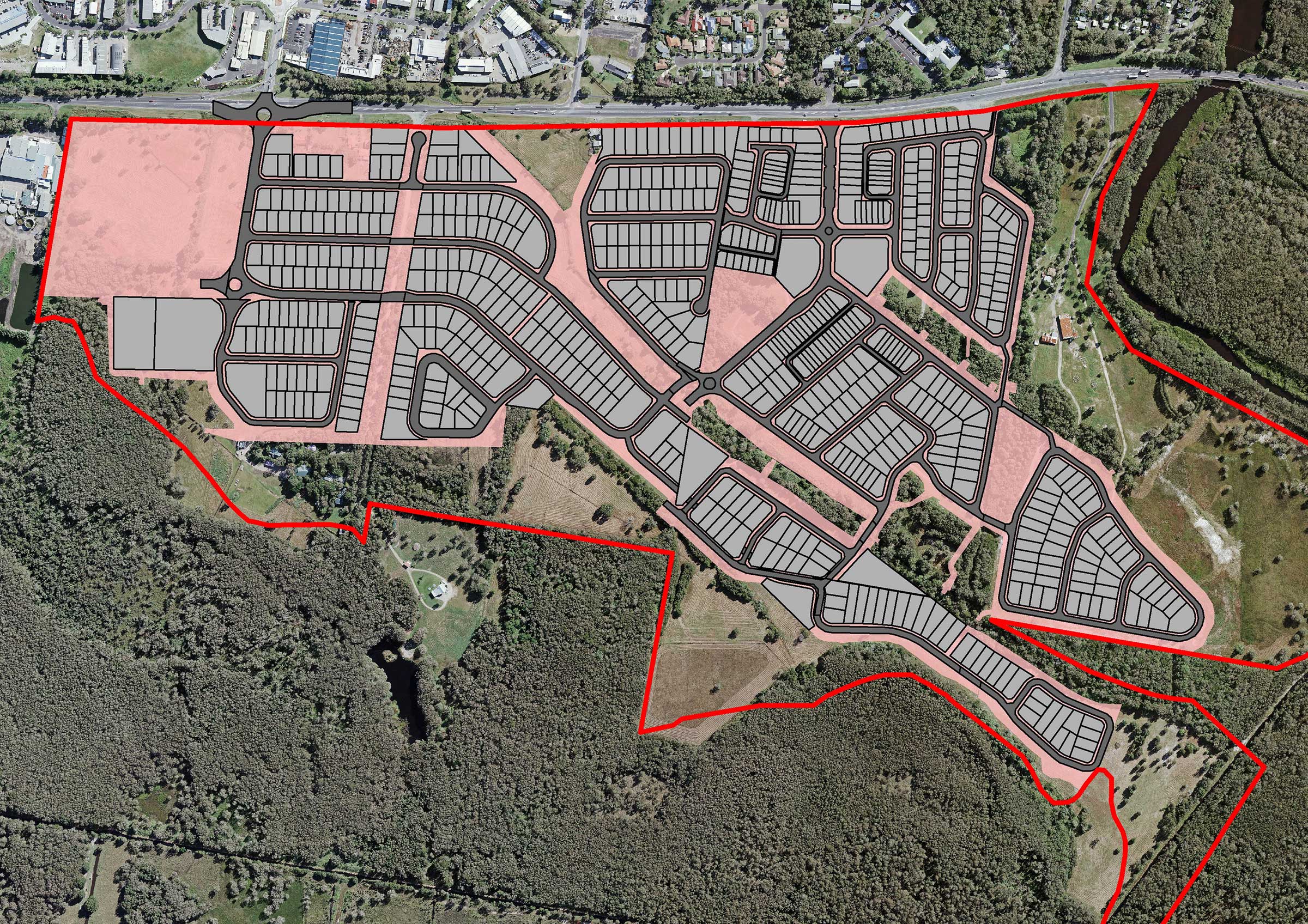
The two exhibited DAs propose to create 659 residential lots from as small as 205m2 up to 3,386m2.
Within the Low Density Residential areas, both DAs are proposing numerous superlots which, contrary to the rules, are intended for future subdivision into medium-density housing or flats.
Minimum lot sizes have been flouted in the low-density zone with house lots down to 380m2 (450m2 minimum size), and duplex lots down to 525m2 (600m2 minimum size).
When subdivision rules are applied to the proposed lots it is apparent the proposals will result in more than 1,000 dwellings (without accounting for secondary dwellings). Ewingsdale Road is the main route into Byron Bay and is increasingly suffering congestion in peak periods.
Traffic increase
Traffic is now in excess of 20,000 vehicle trips per day in the off season.
The developers are now admitting that their development will result in more than 14,000 daily vehicle trips, though I estimate it will add more than 16,000 vehicle trips per day onto Ewingsdale Road.
I have long argued that the zoning of this site was approved by the minister for planning on the patently false premise that it would only result in 6,000 additional vehicle trips per day, and that my repeated attempts to have the Department of Planning and Byron Shire Council acknowledge and redress this since 2011 were unjustly ignored.
The developers are denying that all those cars and two additional roundabouts (or traffic lights) will have any significant effect, when they will obviously have major and dramatic effects on the efficiency and ongoing operation of Byron’s main road in contravention of clause 101 of State Environmental Planning Policy (Infrastructure).
Below flood level
The proposals involve filling the site to above flood level, with the importation of a million tonnes of fill. There is no indication of where this will come from and no assessment of the impacts of all those trucks on Ewingsdale Road.
The site will be filled up to 2.5m above Ewingsdale Road with a 2m or higher sound wall above this. Council is proposing that a 6m wide landscaped mound (and 5m wide path and utilities corridor) will extend into the public road reserve to obscure this massive wall. The wall should be set back from the road and the needed visual buffer put on the developer’s own land, so that we can retain our most important public transport corridor for just that.
The proposals are to clear 10.6 ha of native vegetation, of which 1.8 ha is in environmental protection zones.
Villaworld revised their proposal to remove the need to clear in environmental zones, but the local landowners have drains, paths and roads through them, with one area to be cleared for no apparent reason.
There are 13 patches of wetlands totalling 2.1 ha proposed for filling that have been identified in the government’s draft State Environment Planning Policy (Coastal Management) as warranting an Environmental Impact Statement, except the SEPP hasn’t been adopted yet.
One of these wetlands encompasses habitat for the nationally vulnerable Wallum Sedge Frog.
Even though Villaworld are proposing to place 3m of fill over the only known population on their property, they refuse to assess impacts and prepare a Species Impact Statement on the grounds it ‘will be subject to a Bio-banking Assessment Report’.
The local landholders remain in denial about the critical importance of the habitat on the site for facilitating essential dispersal of koalas between Tyagarah and Byron Bay, despite all surveys over the past eight years finding koalas or fresh scats on the site.
Plans to clear koala habitat
Their intention is to clear two of the 5.5 hectares of koala habitat, fragment the remaining habitat, and put up koala-proof fences – all of which threaten the functioning of this vital link. They think that it’s equivalent to cut down mature koala feed trees and replace them with seedlings that will take decades to be useable.
They have even failed to consider their impacts on threatened species in accordance with the new Biodiversity Conservation Act, as legally required.
The Department of Planning has previously flouted the planning rules so the minister could insert the developer’s grandiose scheme into Byron’s Local Environment Plan (LEP).
Rules ignored
This appears to have emboldened the developers into ignoring their own rules.
This may be your last chance.
You need to make a submission to say enough is enough. Both DAs need to be withdrawn and made compliant with all legal requirements.
Whatever the developers do, Ewingsdale Road will not cope with the traffic increases, and their traffic nightmare should be rejected for past misrepresentation and contravening clause 101 of the Infrastructure SEPP.
♦ Dailan Pugh is spokesperson for the North East Forest Alliance (NEFA).


West Byron was always a hideous development idea right from conception.
Plus, it’s stupid. A desperate grab for $$$ with no further planning considered … typical behaviour from this type of developer.
If anything, the entire site should be reclaimed as a west byron wildlife reserve wetland sanctuary and managed by NSW National Parks.
for starters council would be well advised to ban any increase in density from the outset- ie no second dwellings on any of the properties in there to help keep it purely residential.
Koalas are in trouble but they are fairly easy to observe and they can eat the leaves of young trees. I’m worried about the possible loss of big trees with hollows that can take 100-200 years to replace. Has anyone investigated what mammals (eg gliders) and other creatures are using these on the site?
Does anyone know how many submissions council needs to wake up and grow some balls and stop this insane development… ? Locals, let’s get our act together and act! Does anyone have any suggestions on how to communicate our opposition to this greed … after our submissions are sent in?
The wetlands ( or the lungs of Byron ) are about to get cancer !!
I’m with BC and Will on this. Also This will undoubtedly put stress on Skinners Shoot Road as well with higher flood levels as a result of the extra fill…a million tonnes! Are they seriously thinking they will get away with this? Not if I can help it.
Obvious madness but that’s how they run Australia. Common sense says Byron is already full to capacity with ocean north and east and swamp to the west limiting space for infrastructure to accommodate further development.
On the subject of fill and floods, even if the flood level has a maximum height of only half a metre, that is still a hell of a lot of cubic metres of water that will lie on land somewhere adjacent to the area of fill, and flood somewhere else a lot worse than has happened before.
The traffic situation will gridlock Byron as there isn’t the parking capacity or the capability of the roads to process such traffic volumes efficiently.
I’ve previously suggested a circular one way system in central Byron to minimise traffic delays such as roundabouts and junctions and in doing so, maximise the number of vehicles that can flow on a road per hour.
The Butler street bypass is more a gesture than a solution with the current traffic flow and the West Byron development is a nightmare in the making even in the winter season, let alone peak season.
Yup, total madness, but the minister, the developers and others with a buck to make or a quota of new houses to fill, will undoubtedly have their way irrespective of studies and rules and common sense on any of the multiple issues.
Rules will be broken and bent, promises made and never kept and the people of Byron and the visitors will suffer.
Great idea to make the area a protected wildlife sanctuary but never going to happen as proven by similar areas of land being grabbed and developed in Ballina and on the Gold coast
How would Byron even function with that much estimated extra traffic on the already piddling potholed Ewingsdale Rd????. Byron Shire Council can’t even fix that so i feel an impending sense of doom. Goodbye Byron it was nice knowing you.
The responsibility for this development lies with the Planning and Assessment Commission, (PAC) which was the invention of the dodgy state Labor government, specifically to override council policy and community concerns about such massive developments.
Unless there’s a shire/state wide community effort to have the PAC abolished and planning decisions on major developments given back to council and the community, the West Byron development, and Mega Festivals at Yelgun, will just be the start of this kind of environmental destruction.