Could vacant land adjacent to the Brunswick Valley Sewage Treatment Plant (BVSTP) become home to an affordable housing village where residents can walk or ride along the rail trail into the centre of Mullumbimby?
This is an idea being considered by Byron Shire Council this year following a new report which provides much-needed clarity about the future of the picturesque northern Shire site.
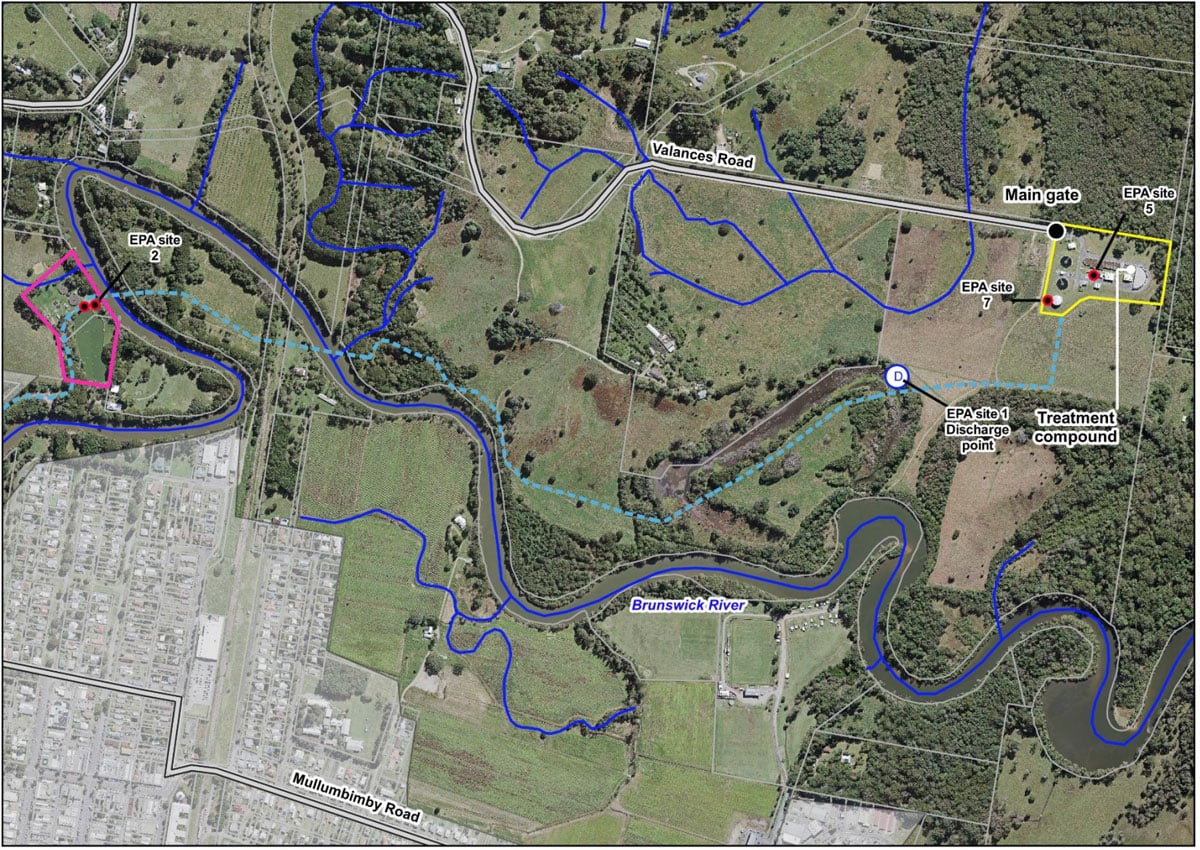
Discussions for use going on for a decade
Discussion about what should be done with the large, undulating parcel of land at the end of Vallances Road, Mullumbimby, has been going on for more than a decade.
Bounded by the Brunswick River and with the old, unused northern rail line running through the middle, much of the site is owned by Council or the state government, giving it potential for use in a socially useful way.
Multiple community groups have vied for a piece of the stunning spot over the years, with proposals including a natural burial ground, a social housing project, and spaces for community organisations such as Queer Family Inc and the Mullumbimby Men’s Shed.
However, each of these projects have been either stymied or abandoned completely, owing to uncertainty about the future expansion needs of the sewage treatment plant, and the other considerable issues which constrain use of the site.
A new report by Council staff has provided some clarity on the future land use needs of the plant.
The report outlines how the BVSTP may well take on significant additional sewage load if – as expected – the Council elects to decommission the ageing and overburdened Ocean Shores Sewage Treatment Plant.
Staff have calculated just how much additional land at Vallances Road would be needed to accommodate this expansion, including a projected 400 metre ‘smell buffer’ around the entire site.
This would still leave a sizeable proportion of land – some of it Council owned – for other uses, and Council is considering including some of this land in its residential strategy.
It will also conduct a review of the 2017 Plan of Management (POM) for the site with an eye to possible future uses.
Greens Councillor Elia Hauge, who moved that the POM for the site be reviewed, said that a range of uses should be considered.
‘There are some parts of the site which are out of the flood zone which could be amazing opportunities for community buildings,’ Cr Hauge said.
‘We have a number of community organisations, like the Men’s Shed, like Queer Family Inc, who are quite keen to have some land in the Shire.
‘We should also consider the environmental considerations – making sure the riparian zones are still being regenerated.’
‘This is a great opportunity for us as a new Council to consider this incredibly important site and all of the potential that it holds for our community.’
Deputy Mayor Jack Dods (Independent) said the site had potential for ‘much-needed affordable and attainable housing’.
‘This would be the perfect site for an urban peripheral Eco Village for people to live and work,’ Cr Dods said.
‘And it would be way quicker for people there to walk or ride along the rail trail straight into the heart of Mullumbimby than it would be to drive.
‘It’s potentially a great example of how you could design and develop sustainable villages on the edge of towns, that utilise rail trails as a spine, and to incentivise trips to work and school and to the shops on foot or on bike.
‘It’s flood-free, it’s an excellent portion of land. Until now it’s been constrained by the overly liberal application of the STP buffer, so it’s excellent that this work’s been done.
‘It’s exciting to see that it also leaves the western third of Council-owned land at Vallances Road also outside of that buffer. So amending the POM to investigate potential uses there is very exciting.’
Cr Dods later indicated that the topography of the site could potentially be ‘amended’ to facilitate more housing.
However, having watched many plans for this site come and go, the community could be forgiven for a degree of skepticism regarding the current ideas being put forward.
Not only does the site’s location right next to the Brunswick River make much of the land severely flood-prone and susceptible to being cut off from town, but the main road access via the intersection of Vallances Road and Coolamon Scenic Drive is also a road safety blackspot.
There is also the issue of private ownership around some key sections of the site.
 For four decades The Echo has printed the stories some people loved, some people hated, and some pretended not to read. If you want us to keep telling the truth, the real truth, not the sugar-coated version. We’ll need your support to keep the presses rolling.