Updated 5:50pm Thursday: Minor flood warnings are in place for the Tweed, Richmond/Wilsons and Brunswick river valleys
Additionally a flood watch for moderate to major flooding is current for the Tweed Valley as more heavy rainfall is expected tonight.
At Murwillumbah, with forecast rain, the Tweed is predicted to exceed minor flood level (3 metres) around 1am Saturday morning, with further rises expected
At Chinderah it is predicted to reach minor flood level (1.3 metres) around 8pm tonight with the high tide.
The Wilsons River at Lismore is predicted to exceed minor flood level (4.2 metres AHD) around 3am Saturday morning. Further rises are expected with predicted heavy rain.
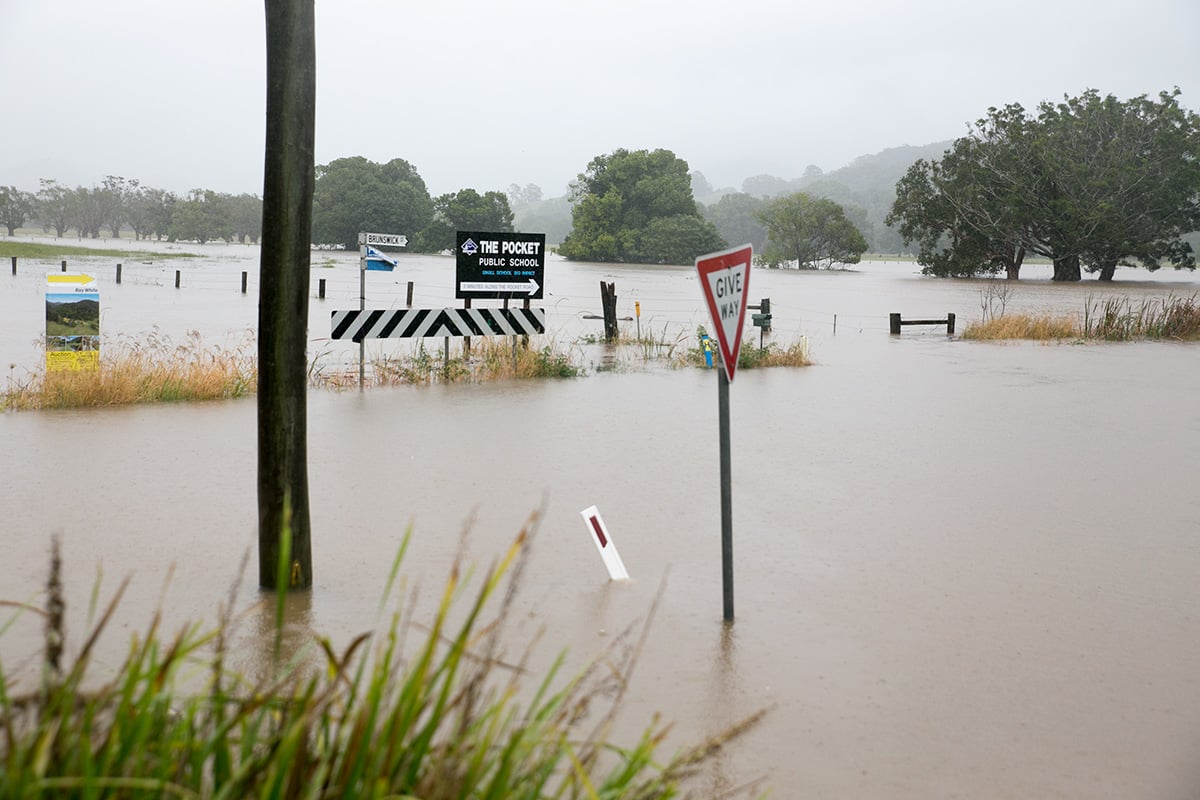
The Brunswick River with forecast rain is predicted to exceed minor flood level (2.5 metres) around 9pm tonight at Billinudgel and minor flood level (2.5 metres) around 1am Saturday morning at Mullumbimby.
Further rises are expected.
Road closures
As at 5pm Friday a number of roads were already closed, including: Cobaki Road (bridge flooding); Coolgardie Road at Kays Road intersection; Dibbs Street, Lismore; Friday Hut Road at Kirklands Crossing; Houghlahan Creek Road causeways; Lindendale Road at Marrom Creek; Marom Creek Road at Gum Creek; Pearces Creek Hall Road at Pearces Creek; Swan Bay – New Italy Road at Darke Lane; Tyagarah Airstrip; Urliup Road, Bilambil, Wyrallah Road at Duriehm Road.
Motorists are urged to postpone any non urgent travel and check myroad.info for updated conditions before setting out.
Saturday
More thunderstorms are predicted, together with heavy falls exceeding 110 mm on and east of the ranges. Winds east to southeasterly 35 to 55 km/h decreasing to 20 to 30 km/h in the morning then becoming light in the afternoon. Overnight temperatures falling to between 9 and 15 with daytime temperatures reaching between 14 and 20.
Sandbags
Residents wanting sandbags should phone SES on 132 500.
Property damage
If residents have property damage, phone SES on 132 500. For life threatening emergencies please phone triple zero (000).
Stay informed
Residents are advised to stay informed by listening to their local radio station or checking the BOM’s official weather warnings at www.bom.gov.au
Keep up to date with weather warning at the Bureau of Meteorology at http://www.bom.gov.au/nsw/warnings/.
To find out if the beaches are open or closed, visit www.beachsafe.org.au
Byron Shire information
Byron Shire Council director of infrastructure services, Phil Holloway, is urging residents and visitors to drive to conditions and check My Road Info (www.myroadinfo.com.au) before venturing out.
‘The severe weather warning and east coast low, is likely to cause some road damage with potholes, see trees fall over roads and drains struggle to cope with large amounts of water.
‘Similarly, very heavy surf conditions could see our beaches closed.
‘Whilst our beach profiles are healthy, we could see some coastal erosion. The powerful surf is also likely to make conditions unsafe and restrict beach access.
‘It is best to avoid the beach over the next few days, but if you do go, check the tides and try to avoid the high tide.’ Mr Holloway urged.
Water is currently over Friday Hut Road at Kirkland’s Crossing and all sportfields are closed. Tyagarah airfield is closed.
Council crews have also inspected pumping stations and major drains, and yesterday removed a tree over the road near the Crystal Castle.
Residents and visitors are also cautioned to stay away from swollen creeks and waterways and not cross flooded causeways or roads with water lying over the top.
Byron Shire Council staff will continue to monitor the roads, coastline and waterways and erect signage and barricades where needed..
Fallen trees and road damage can be reported to Council during weekdays 8.30am to 4pm on 6685 9300. On weekends and after hours, phone 6622 7022.
Find out how you can be prepared for flood (http://www.floodsafe.com.au/) and storm events (http://www.stormsafe.com.au/) and put together your emergency plan (http://www.seshomeemergencyplan.com.au/).
Byron Shire sportfields closure www.byron.nsw.gov.au/sporting-field-status
Ballina Shire information
Heavy rainfall can put extra pressure on the sewerage system due to floodwater infiltration. Backing up of water or slow draining water may occur in lower lying areas. If this is occurring in your area please be patient and allow for the discharge to escape by refraining from using internal water, such as washing machines, dishwashers, baths and showers until the water has cleared as this further loads the system.
Residents are advised that it is not necessary to boil drinking water. The water and sewer systems are very separate systems.
Beaches may experience coastal erosion, possibly impacting beach access tracks and coastal dunes. It is recommended to stay away from beaches, and exercise extreme caution after the weather event due to erosion.
The Ballina Byron Gateway Airport is open and operational. There are currently no cancellations. If travellers are in doubt they should contact their airline direct:
Rex 131 713 rex.com.au
Jetstar 131 538 jetstar.com
Virgin Australia 136 789 virginaustralia.com.au
Updated 7:50am Friday: Rainfall totals were less than feared overnight but weather forecasters say the east coast low that will dominate weather on the weekend is still forming to the north.
A tree is reported over road between Coolamon Scenic drive and Crystal Castle.
Motorists are urged to take care on the roads today, not drive through flooded causeways and postpone non-essential travel.
Currently all roads in our region remain open but Tyagarah Airstrip has been closed as a precaution.
The Echonetdaily ‘weather station’ at Binna Burra has received 92mm of rain in the past 48 hours, including 22mm overnight.
Local (24hr) totals reported to ABC North Coast include: Upper Wilsons Creek 37mm, Mullum Creek 29mm, East Ballina 20mm, Grafton 11mm, West Tweed Heads 82mm (117mm in 48hr), Kingscliff 58mm, and East Lismore 47mm.
SES have set up sandbagging points for the public.
A spokesperson told ABC the weather was set to become more hazardous ‘with thunderstorms forecast heavier rain in particular locations and with wet ground trees could come down and some people looking at being flooded in low lying areas’.
She that said local SES numbers would be swollen by volunteers from as far away as Victoria, with additional support provided by 16 police rescue boats and two emergency helicopters.
The bureau predicts a 100 per cent chance of rain, very heavy at times and the chance of a thunderstorm.
Winds today will be east to southeasterly from 15 to 25 knots increasing to 20 to 30 knots in the morning. Winds increasing to 30 to 40 knots later in the afternoon and evening and tending east to northeasterly, possibly reaching 45 knots at times.
Seas will have 1.5 to 2 metre swells, increasing to 2 to 3 metres during the morning, then increasing to 4 to 5 metres during the afternoon.
Deceptively powerful surf conditions are expected to be hazardous for coastal activities such as crossing bars by boat and rock fishing.
Forecasters are now hoping the east coast low will clear the northern rivers by midday tomorrow.
Updated 4:30pm Thursday: Weather is continuing to worsen in the northern rivers, with rainfall exceeding 100mm reported in some areas over the last 24 hours, gale warnings current and a flood alert continuing.
The bureau forecasts that severe thunderstorms are likely to produce heavy rainfall that may lead to flash flooding over the next several hours in areas around Lismore and Grafton.
Onshore winds and rain will increase as a trough deepens off the northern New South Wales coast today and on Friday. An East Coast Low is expected to form within this trough on Saturday near southeast Queensland before moving south to be offshore of the Mid North Coast on Sunday.
Heavy rain which may lead to flash flooding is forecast from tonight (Thursday) for the northern rivers forecast district. It is expected to intensify during Friday.
In the 24 hours up to 3pm today (Thursday April 30), Lake Ainsworth had received 104mm of rain, Ballina 95mm, Evans Head 91mm, Tweed Heads 54mm and Woodburn 53mm.
A gale warning has been issued for the Byron and Coffs coasts and a flood watch remains in place for the Tweed, Brunswick, Richmond/Wilson and Clarence river valleys.
Original report, 7am Thursday: There will be more heavy weather with possible flooding across most of the northern rivers this week, the bureau predicts.
Already there have been widespread falls overnight, with Ballina recording 100mm and Echonetdaily’s Binna Burra ‘weatherstation’ sitting on around 60mm.
But much more is expected, with up to 350mm in some spots.
No flood warnings have been issued yet but a BoM ‘heads up’ advises residents to be cautious.
Onshore winds and rain will increase as a trough deepens off the northern NSW coast on Thursday and Friday. Another east coast low is expected to form within this trough on Saturday near the Queensland border before moving south to be offshore of the mid north coast on Sunday.
The northern half of the coast (mid north coast and northern rivers) will receive the heaviest rain with multi-day falls of 150-200mm, locally 350+mm from Wednesday night to Saturday. Friday and Saturday will see the heaviest widespread falls.
At this stage there is a greater than 70 per cent chance of flooding in the following river valleys developing during Friday and Saturday:
- Tweed River valley – moderate to major flooding
- Brunswick River valley – moderate to major flooding
- Richmond and Wilsons River valley – moderate to major flooding
- Clarence River Valley, including the Orara River – minor to moderate flooding
This Flood Watch means that people living or working along rivers and creeks must monitor the latest weather forecasts and warnings and be ready to move to higher ground should flooding develop.
Flood Warnings will be issued if the minor flood level is expected to be exceeded at key sites along the main rivers. Across NSW more than 70 per cent of Flood Watches are followed by flooding within the catchment.
FloodSafe advice is available at www.ses.nsw.gov.au
For emergency assistance call the SES on telephone number 132 500.
For life threatening emergencies, call 000 immediately.
 For four decades The Echo has printed the stories some people loved, some people hated, and some pretended not to read. If you want us to keep telling the truth, the real truth, not the sugar-coated version. We’ll need your support to keep the presses rolling.