
Updated, 6.15 pm: The SES is directing residents of Lismore CBD, North and South Lismore, Tweed Heads South and West, South Murwillumbah, Condong, Tumbulgum, Bilambil, Chinderah and Fingal to evacuate where safe transit exists and they are able to do so.
All in all, some 40,000 residents are affected.
Residents are urged not delay their evacuation. Roads will be congested or closed. You could become trapped and need rescue. Remaining in flooded areas is dangerous and may place your life at risk.
Wherever possible, people should go and stay with family or friends, or make other accommodation arrangements. For people who need assistance an evacuation centre has been set up at Kings Sacred Heart (Catholic Hall) Murwillumbah Street, Murwillumbah.
Rocky Creek Dam has reached Amber Alert due to the significant rainfall. The structural integrity of the dam remains intact.
The dam levels are being closely monitored and if current rainfall intensity continues this alert may escalate tonight. The dam level is currently 1.03m over the spillway and continuing to rise.
Residents downstream of the dam are asked to commence preparation for evacuation.
Please continue to listen to your radio for further updates and instructions.
As you evacuate you should;
• Take your important documents, mementos and photos.
• Take your spare clothing, medicines and personal hygiene supplies.
• If going to the evacuation centre take blankets/sleeping bags, pillows and sleeping mats.
• If possible, check to see if your neighbours need help.
• Turn off the electricity and gas.
• Never drive ride or walk through floodwater.
• Continue to listen to a local radio station for updates.
For emergency help in floods and storms, call the NSW SES on 132 500NSW SES website: www.ses.nsw.gov.au
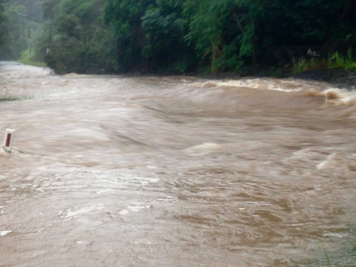
The SES are again imploring people not to drive or walk through flooded causeways after a photo emerged this morning showing two people trying to help move a small car semi-submerged in floodwaters at Sherrys Bridge, Main Arm.
Tamara Cameron, who witnessed the event and took the photo, told Echonetdaily, ‘the car was pulled out of the water by locals, then the SES, firefighters and police arrived.’
An SES Facebook post warns motorists, ‘Our river systems, creeks and springs are already full and it will take little water this time to flood our hinterland causeways!
‘If you are living above the causeways please be aware they may not be passable for a few days,’ it continues.
The storm has hit worst in the Tweed, where conditions have forced the closure of a number of roads and council facilities.
Flood warnings
A major flood warning has been issued for the Tweed River, with conditions comparable to the 2001 and 2008 floods, the BoM reports.
The Bureau of Meteorology (BoM) has issued major flood warnings for the Tweed and moderate flood warnings for the Brunswick and Wilsons rivers after more than 200mm of rain fell overnight in their catchments and a similar amount predicted to fall in the next 24 hours.
Upper Main Arm received 114mm in the 24 hours to 9am, Stokers Siding 120mm, Upper Wilsons Creek 120mm and Murwillumbah 126mm.
In the Tweed, Doon Doon reported 211mm, Couchy Creek 214mm and Chillingham 212.
But the rain has been far from even, with Byron Bay reporting just 15mm in the 24 hours to 9am, Ballina Airport 34mm and Lismore Airport 74mm.
With as much or more rain still on the way, bus lines have cancelled or changed some routes and some schools have been closed.
Tweed River – major flooding
Major flooding is occurring along the Tweed River at Murwillumbah. Moderate flooding is predicted at Chinderah tonight with the high tide.
Up to 417 millimetres of rain has been observed during the 24 hours to 5:00 pm Thursday over the Tweed River valley, and there has been significant river level rises in the valley.
The Tweed River at Murwillumbah may reach around 5.60 metres late Thursday evening with major flooding.
The Tweed River at Chinderah (Barneys Point) is expected to exceed the minor flood level (1.30 m) around 08:00 pm Thursday. The river level may reach around 1.90 metres late Thursday evening with moderate flooding on the high tide. Further rises are possible.
Wilsons River – major flooding
Major flooding is forecast along the Wilsons River at Lismore Thursday night, with river levels predicted to be higher than the 2001 and 2005 floods. Further rises are possible with rainfall forecast overnight tonight.
Up to 430 millimetres of rain has been recorded during the 22 hours to 08:00 pm Thursday over the Wilsons River valley.
The Wilsons River at Lismore is expected to exceed the moderate flood level (7.20 metres AHD) Thursday evening. The river level is expected to exceed the major flood level (9.70 metres AHD) late Thursday evening and is likely to reach around 11.00 metres AHD early Friday morning with major flooding and likely breaching The Lismore levy. The levy, put in place in 2005, has never been tested until now.
Brunswick River & Marshalls Creek – minor flooding
Up to 248 millimetres of rain was observed during the 12 hours to 12:30 pm Thursday over the Brunswick valley.
Minor flooding is predicted along the Marshalls Creek at Billinudgel, which is likely to reach the minor flood level (2.50 m) late Thursday afternoon.
Minor flooding is predicted along the Brunswick River at Mullumbimby (Federation Bridge), which is likely to reach the minor flood level (2.50 metres) Thursday afternoon.
Gale warning
A gale warning has been issued for the Byron coast for today and tomorrow, with wind expected to strengthen tomorrow and into Saturday.
Road closures
In Tweed Shire, the following roads are closed due to flooding: Bilambil Road; Cobakai Road; Crabbes Creek Road; Kyogle Road at Byangum Bridge and Sharps Road; Limpinwood Road; Mooball Pottsville Road; North Arm Road; Numinbah Road at Nobbys Creek; Palmvale Road at Palmvale; Piggabeen Road at Cobakai; Stokers Road, north of school; Terranora Road at North Tumbulgum; Tumbulgum Road, Murwillumbah; and Tyalgum Road at Rocky Cutting, Tyalgum and Kyogle Road intersection.
In Byron Shire, the following roads are closed: Booyong Road and Booyong Bridge; Coral Avenue, Mullumbimby, Dingo Lane, Myocum; Gooengerry Road; Left Bank Road, Mullumbimby; Main Arm Road (water over Sherrys Bridge); Myocum Road at James Lane, Coolamon Scenic Drive and Myocum; Palmwoods Road beyond Main Arm Shop; Repentance Creek Road; The Pocket Road; Upper Main Arm Road; Upper Willsons Creek Road.
In Ballina Shire, the following roads are closed: Boundary Road at Marom Creek; Lindendale Road at Marom Creek, Marom Creek Road at Gum Creek; Dalwood Road at Gum Creek Weir; Friday Hut Road at Kirklands Crossing; Houghlahans Creek Road causeway; and Pearces Creek Hall Road at Pearces Creek. Parts of Ballina CBD are subject to tidal inundation.
In Lismore LGA, the following roads are closed: Bentley Road causeway at Tullera; Brewster Street at Lismore Square; CAnaiba Road west of Roadrunner Caravan Park; Corndale Road near Corndale Public School; Cross Road Numulgi; Cusack Road, North Lismore; Dunoon Road, North Lismore; Durheim Road Monaltrie (near Wyrallah Road intersection); Hensley car park; Lindendale Road; Magellan Street between Brewster and Diadem Streets; Monaltrie Road, Monaltrie; Nimbin Road, south of Koonorigan Road; Numulgi Road, south of Lockton Road, Numulgi; Lismore Rowing Club car park; Sibley Street, Nimbin; Snow Street, South Lismore; Terania Creek Road, Terania Creek; Tuntable Creek Road, near the school and near Arkinsall Road; and Wyrallah Road, near the East Lismore Treatment works.
Flood safety advice
FloodSafe advice is available at www.ses.nsw.gov.au
For emergency assistance call the SES on telephone number 132 500.
For life threatening emergencies, call 000 immediately.
 For four decades The Echo has printed the stories some people loved, some people hated, and some pretended not to read. If you want us to keep telling the truth, the real truth, not the sugar-coated version. We’ll need your support to keep the presses rolling.