The development of 742 residential lots, two neighbourhood business lots (super lots), one residue lot (future residential) and 45 new roads on the North Lismore Plateau (NLP) has been recommended for refusal by the Lismore City Council (LCC) assessment. There is no affordable or social housing component within the development.
The decision on the development application (DA) will be made by the Northern Rivers Planning Panel (NRPP) on 15 December as the proposal has a capital investment value of more than $30 million.
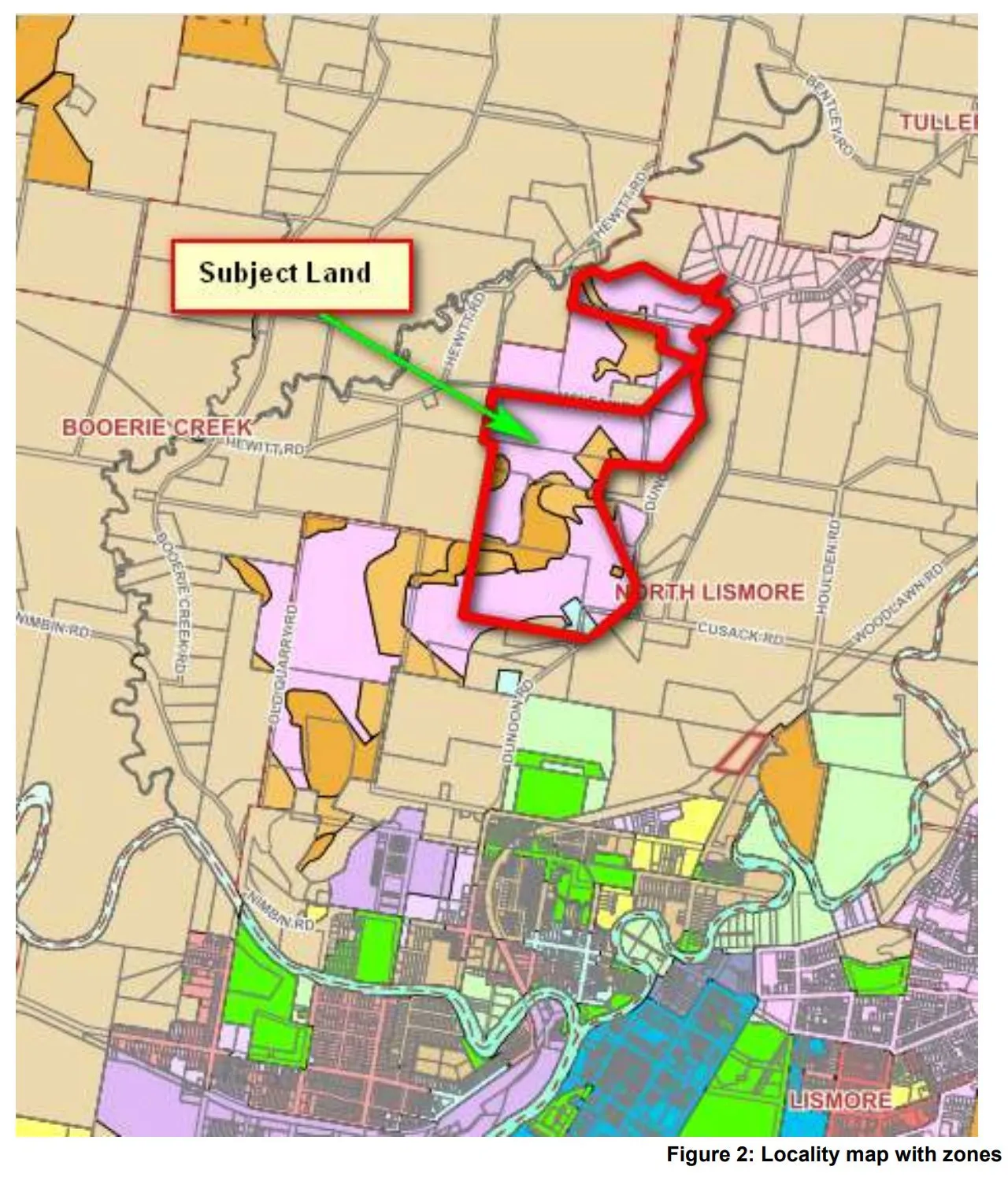
‘The NLP development proposed by a coalition of land owners is the single biggest DA in Lismore since the subdivision of Goonellabah,’ said Al Oshlack who has been working with Bundjalung man Mickey Ryan on the impact of development on the NLP for over ten years.
The Council development assessment report highlights the failure of the developer to respond to a number of issues raised at the formal pre-lodgement meetings with Council on 11 December 2018 and 25 March 2021.
‘Formal minutes of the meeting were provided to the applicant that provided an outline of the technical reports required and matters to be addressed in any future development application to be lodged with Council. Many of the issues initially raised in the pre-lodgement meeting(s) remain outstanding,’ states the assessment.
The site for development sits in the drinking water catchment the Rous County Council (RCC) ‘recommended that the stormwater treatment regime be designed with consideration the development is located within a water supply catchment and that a neutral or beneficial effect on water quality test be applied to any proposed stormwater management approach’. However, the developers failed to provide the required information and ‘[T]his aspect of the application remains outstanding,’ stated the report.

Filling in a watercourse
The proposal to completely remove and fill and pipe a second-order watercourse was a key issue for the NSW Natural Resources Access Regulator (NRAR) NRAR. They stated that ‘[T]he removal of a 2nd order watercourse is not consistent with NRAR guidelines and is not supported by NRAR. NRAR has requested that the subdivision layout be amended so as to maintain this 2nd order watercourse and associated riparian zone in accordance with NRAR guidelines’.
While only a small area of the site is affected by the 1 per cent AEP flood event with a level of 12.9m AHD the report concludes that ‘additional commentary considering the February 2022 floods is still required to afford whether matters need to be redressed and or any significant variances arise out of reviewing the context of that flood to those previous.
Mr Oshlack told The Echo that ‘parts of the development on the Dunoon Road floodplain was inundated in the 2022 February/March floods’.

Aboriginal heritage
The impact on Aboriginal Cultural Heritage was a ‘significant shortfall with the application’. The independent review of documentation provided for the DA was done by Mr Neville Baker of Baker Archaeology who summarised that the ‘material fails to meet Council’s statutory requirements in fulfilling due diligence’. The DA also failed to address the impact on Aboriginal cultural heritage under the local environment plan (LEP) in relation to areas of ‘high ecological, scientific, cultural or aesthetic values’ and to ‘ to conserve archaeological sites.. [and] places of heritage significance’ among others.
Lack of service supply
For any new development, the supply of water and sewer facilities are essential. However, the site currently has no infrastructure for these in place. The report states that there ‘is insufficient information in regard to the provision of the supply of water and reticulated sewer for Council to be satisfied that the proposed development complies’.

Significant earthworks
To achieve the development significant earthworks are required and issues of the impact on neighbours, the local environment and water catchment were raised.
‘There is insufficient information provided to determine whether the application will not have a detrimental impact on environmental functions… It its current form, it is likely that the proposed development will have: a detrimental effect on, drainage patterns and soil stability in the locality of the development adverse impacts on waterways, Wilson River drinking water catchment and environmentally sensitive areas,’ it states.
An Engineering/Traffic/Stormwater Drainage review by council’s development engineer states that ‘given the significance of the outstanding engineering issues that remain to satisfy them, a substantial redesign of the development is required’.
Fire
The developer has sought to have the proposed perimeter for fire risk managed by ‘individual management of a perimeter fire access track’. However, ‘The NSW RFS was unable to support this notion stating that the individual management of a perimeter fire access tracks will not provide a consistent on-going management but rather an ad-hoc haphazard management regime that will render the perimeter fire trails in-accessible.’
Issues were also raised with the impact on increased traffic on Dunoon Road with council stating that they are ‘not satisfied that the safety, efficiency and ongoing operation of the classified road will not be adversely affected’.
The Biodiversity Conservation Act (BAM) 2016 requires a Biodiversity Development Assessment Report (BDAR) if a development is ‘likely to significantly affect threatened species’. They said that the BDAR was no longer available therefore ‘the BAM Credit calculations cannot be assessed’ and that ‘Issues pertaining to Part 7.8 of the BC Act remain outstanding.’
‘Council raised serious grounds which campaigners have been representing for years such as biodiversity, flooding and cultural heritage not to say the 10,000 plus car movements per day predicted for Dunoon Road,’ explained Mr Oshlack.
‘Mickey Ryan who steadfastly opposed over the last 10 years, Council’s support for the development, should be recognised for his courageous foresight to shoulder, not only protection of his Wiyabal cultural identity but relieving our community of a potential multi-million dollar blackhole debt.’
 For four decades The Echo has printed the stories some people loved, some people hated, and some pretended not to read. If you want us to keep telling the truth, the real truth, not the sugar-coated version. We’ll need your support to keep the presses rolling.