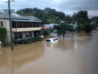
The devastating impacts of flooding in the north of Byron Shire were brought home to the local community during the 2017 floods that resulted from Ex-Cyclone Debbie. Those floods left both businesses and homes in Billinudgel, many of which had never previously been flooded, with severe damage. Similar effects were felt throughout out the shire in Mullumbimby, Ocean Shores, New Brighton, South Golden Beach and Brunswick Heads.
The Draft North Byron Catchment Flood Risk Management Study examines the challenges that these communities are facing as well as the potential future impacts of how and where development will be occurring. It is currently on public exhibition and is open for community feedback.
The Draft North Byron Catchment Flood Risk Management Study focuses on the Brunswick River, Simpsons Creek and Marshalls Creek catchments and provides detailed information on flood impacts, mitigation options, evacuation routes and management of flood events.
‘The new consultants engaged for the second phase have the capacity to fulfil the task. They have had to re-do significant aspects of the 2016 flood study because it fell short and had gaping errors. For example the way the 2016 study had taken some of the modelling parameters well out of their accepted range to try to repair some anomalies in results,’ said Duncan Dey, a member of the flood committee.
Mullumbimby
In the report Mullumbimby is identified as the most flood affected town in the catchment and ‘41 per cent of all flood affected residential properties are located in Mullumbimby’.
The report identifies the high level of sensitivity of ‘Mullumbimby and its surrounds to changes in topography through increased roughness and fill from future development. Simply managing development in the floodway and flood storage area through either prevention or balance cut and fill may not be refined enough to manage these impacts across the study area’, it says.
The impact of developing the area to the south of Mullumbimby called precinct 4 in the Mullumbimby Masterplan (MMP), that includes Lot 22, for residential development (also identified in the Draft Residential Strategy) is of considerable concern to many residents. The community survey, done as part of the study, identified that residents want to ensure that future flood management strategies do ‘not disadvantage other parts of the community’.
Council and land owners in the area identified as the South Mullumbimby (Precinct 4) have been required to produce a separate study for that area as part of their gateway determination. However, this study is not currently available for comment.
‘I’m really pissed off because Council has gone out of its way to do special bits of study for Lot 22 and the south precinct [South Mullumbimby Precinct 4] and has not shared that with the flood committee prior to releasing the draft that is now on exhibition,’ said Mr Dey.
The impact of cumulative development is identified as a key area of concern in relation to flooding of Mullumbimby and surrounds in the draft study. The study’s authors recommend further investigation to provide ‘clear development controls to manage the cumulative impacts from development and an agreed future development footprint that produces an acceptable impact.’
Voluntary purchase
The report recommends investigating the option of voluntary purchase of houses, identifying a possible 15 houses (nine of which are in Mullumbimby) that could be acquired under this scheme. It is suggested that the land is then ‘given over to public space and should be rezoned as an appropriate use such as E2 Environmental Conservation or similar in the LEP so that no future development can take place [on those blocks of land].’
Billinudgel levee
A potential levee for Billinudgel is proposed as well as infrastructure improvements for Billinudgel. In Billinudgel it is proposed to buy back one house. However, dredging of the Brunswick River, its tributaries or the Marshalls Creek is not recommended as a flood management option.
Ocean Shores and surrounds
Similarly no further changes to the rock walls at Brunswick Heads were recommended. While the walls may slow down flood water exiting they also slow down the impacts of ocean inundation, according to the study.
Four houses were recommended for a potential buy back in New Brighton, and areas around Ocean Shores were identified as no fill zones. However, ‘ocean outlets are not recommended as a flood management option’ in the study.
Time to comment
The closing date for submissions for the Draft North Byron Catchment Flood Risk Management Study is 21 February. There will be a community drop-in information session held at the Council offices in Mullumbimby on 7 February from 11.30am – 1.30pm where residents can provide feedback. Copies of the Draft North Byron Catchment Flood Risk Management Study are also available at the Brunswick Heads Library, the general store at Billinudgel, and at Council offices in Mullumbimby or you can access it online on the Byron Shire Council website. www.byron.nsw.gov.au/Home/Tabs/Public-notices/North-Byron-Floodplain-Risk-Management-Study-public-exhibition
 For four decades The Echo has printed the stories some people loved, some people hated, and some pretended not to read. If you want us to keep telling the truth, the real truth, not the sugar-coated version. We’ll need your support to keep the presses rolling.