
NSW State Emergency Service (SES) warns significant storm and flood risk are still possible for Northern NSW and is urging communities to remain vigilant.
‘In the past 24 hours, the NSW SES has been responding to 1,117 incidents. These include 29 flood rescues. NSW SES members have assisted with multiple fallen trees, downed powerlines, and flash flooding,’ said the SES in a press release.
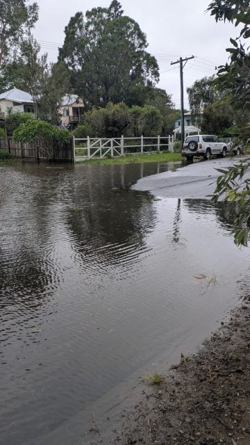
The SES are reminding people not to enter floodwater and to stay informed about local developments.
Lismore
The Bureau of Meteorology (BOM) advises further heavy rain is still possible over the Northern Rivers with ex-Tropical Cyclone Alfred, and there remains a risk of river levels reaching levee heights if intense rainfall develops. River levels near the height of the South Lismore levee may occur during Saturday.
The Wilsons River at Lismore (AHD) is currently at 9.29 metres and rising slowly, above the moderate flood level (7.20 metres). The Wilsons River at Lismore (AHD) may exceed the major flood level (9.70 m) Saturday afternoon. The river level may reach around 10.00 metres late Saturday afternoon or evening with major flooding. Further river level rises are possible with forecast rain.
Tweed River at Tumbulgum
The Bureau of Meteorology advises the Tweed River at Tumbulgum is currently at 1.81 metres and steady, above the moderate flood level (1.80 m).
The Tweed River at Tumbulgum may reach the major flood level (2.50 m) late Saturday morning. Further rises are possible during Saturday into Sunday with forecast rainfall.
Kyogle
The Bureau of Meteorology advises the Richmond River at Kyogle is currently a 14.45 metres and rising, above the moderate flood level (14.40 metres).
The Richmond River at Kyogle is likely to reach the major flood level (16.00 metres) early Saturday morning, with forecast rainfall.

Coraki
The Bureau of Meteorology advises the Richmond River at Coraki is currently at 3.49 metres and rising, above the minor flood level (3.40 metres).
The Richmond River at Coraki is likely to exceed the moderate flood level (5.00 metres) early Saturday morning.
The river level may reach the major flood level (5.70 metres) Saturday afternoon, with forecast rainfall.
Woodburn, Broadwater and Swan Bay
The Bureau of Meteorology advises the Richmond River at Woodburn is currently at 2.39 metres and rising, below the minor flood level (3.20 metres).
The Richmond River at Woodburn is likely to exceed the moderate flood level (3.70 metres) Saturday morning.
The river level may reach the major flood level (4.20 metres) Saturday afternoon, with forecast rainfall.
Bungawalbin
The Bureau of Meteorology advises the Richmond River at Bungawalbyn is currently at 3.10 metres and rising, above the minor flood level (3.00 metres).
The Richmond River at Bungawalbyn is likely to exceed the moderate flood level (4.50 metres) early Saturday morning.
The river level may reach the major flood level (5.00 metres) Saturday afternoon, with forecast rainfall.NSW SES Assistant Commissioner Nicole Hogan said it was important to remain cautious despite the easing of the cyclone.

Returning home
‘Where we are able to, we have downgraded our warnings and are allowing people to return home, such as Bowraville where the threat has reduced,’ Assistant Commissioner Hogan said.
Multiple major flood warnings remain in effect for the Tweed, Richmond, Wilsons, Brunswick, Orara, Clarence, and Bellinger rivers.
‘Although Alfred is now an ex tropical cyclone and winds are beginning to ease, major flooding is still possible in a number of areas which are still subject to emergency warnings,’ Assistant Commissioner Hogan said.
‘It is not currently safe for people to return, until the warnings are lifted, and the threat of heavy rain and flooding has passed. Please continue to stay at evacuation centres or stay with family or friends.
‘I remind you never to drive, ride, or walk through floodwater as they can be deeper and more dangerous than they appear.’
As the weather conditions begin to improve NSW SES members and emergency services will be working to assist with storm jobs, restoring power and clearing roads.
NSW SES crews will be undertaking impact assessments to buildings, homes and commercial properties for both storm and flood damage once it is safe to do so.
If you spot damage to your home or those of your neighbors, contact the NSW SES on 132 500.
The NSW SES is closely monitoring the progress of ex Tropical Cyclone Alfred, which is has the potential to move into the north western areas of the state, before moving further south east towards the Hunter, Sydney and Illawarra areas. Heavy rain, riverine flooding and flash flooding is possible in coming days.
For the latest updates, evacuation centre locations, and emergency information, please visit the NSW SES website at www.ses.nsw.gov.au, download the Hazards Near Me app, or tune into ABC emergency radio broadcasts.
 For four decades The Echo has printed the stories some people loved, some people hated, and some pretended not to read. If you want us to keep telling the truth, the real truth, not the sugar-coated version. We’ll need your support to keep the presses rolling.