
Updated Sunday 11am
The north coast has dodged a bullet as ex-tropical cyclone Marcia continues to break up off the coast without causing a much-feared additional deluge following the already massive falls.
The SES is reported to have attended to more than 700 calls for help during the last three days.
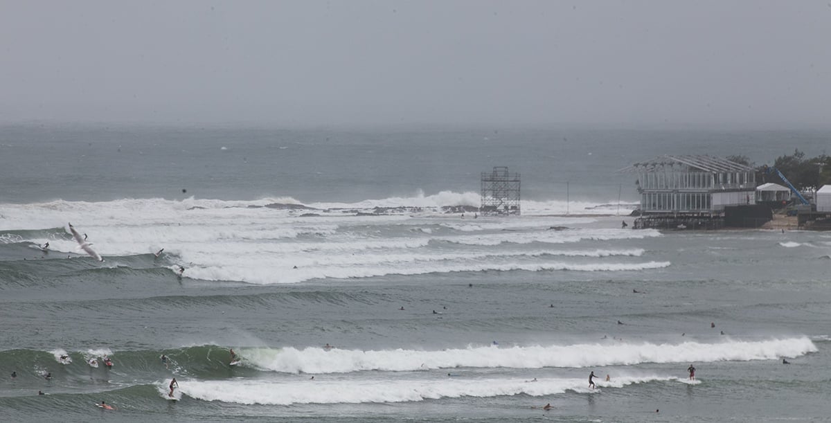
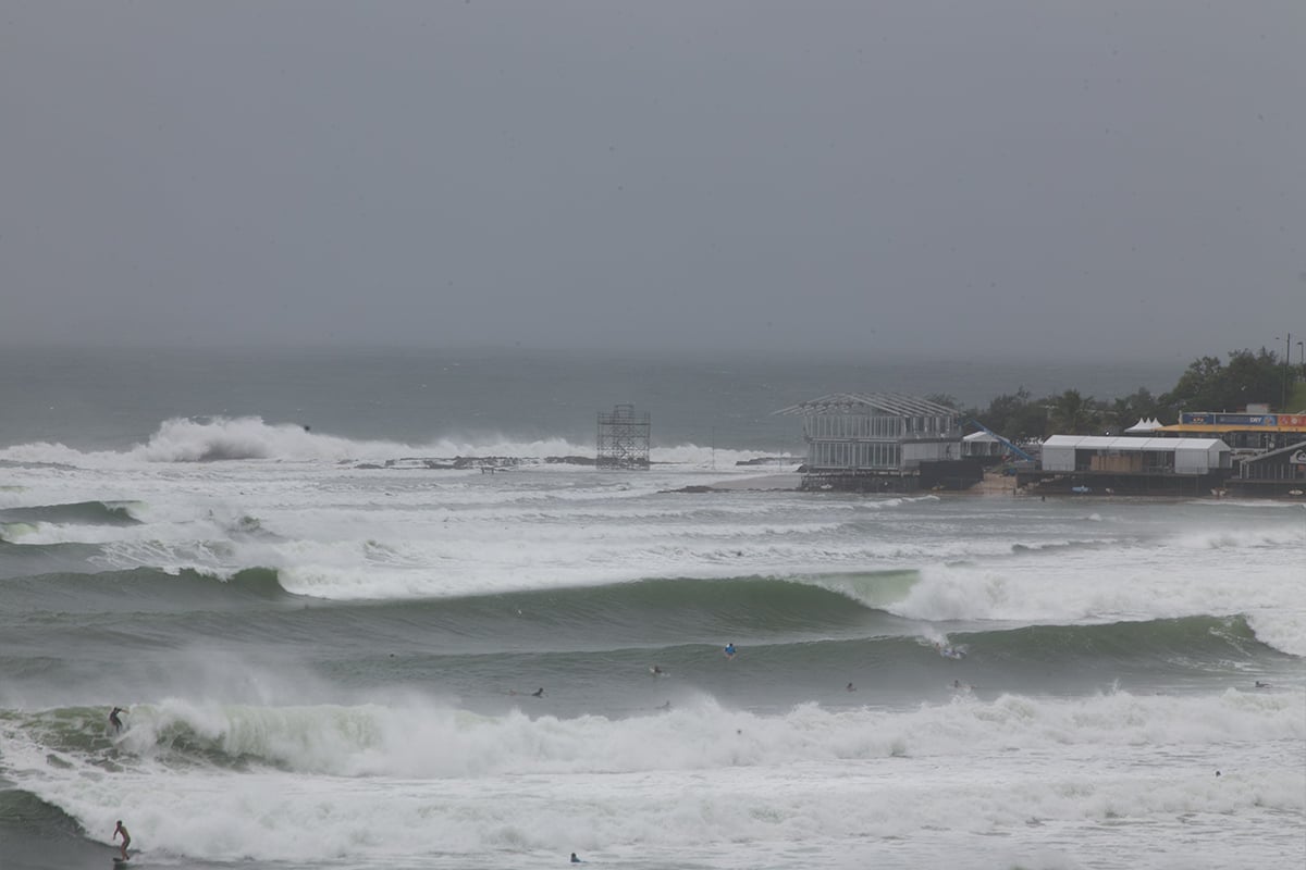
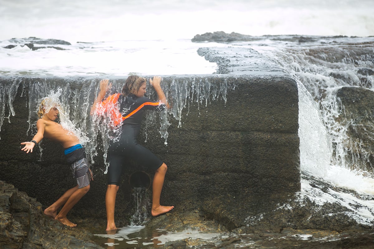
The focus now turns to the coastline where peak tides and heavy surf conditions are causing erosion along exposed beaches.
The above photo, showing how high water came up Byron Bay’s Main Beach was taken at 10am on Saturday. (Scroll down for more photos.)
Large and powerful surf conditions are expected to continue, posing hazards for coastal activities such as rock fishing, swimming and surfing.
The Bureau of Meteorology (BOM) has advised of a more powerful round of swell (than currently experienced) may impact the north coast beginning Sunday afternoon.
Send your storm and beach erosion photos to [email protected]
The forecast swell conditions are for Sunday, Monday and Tuesday. Exposed north coast beaches may experience coastal erosion, possibly impacting beach access tracks and coastal dunes. It is recommended to stay away from beaches, and extreme caution will be needed even after the weather event due to erosion.
SES spokesperson Phil Campbell said the damage caused by wind overnight was minor.
‘We have had strong winds up in northern NSW with some gusts up around 90 kilometres per hour at Cape Byron,’ he told ABC.
‘This has resulted in some minor property damage with some trees and branches down. But fortunately these winds have not been as bad as expected, rain has eased and flooding is not expected to worsen,’ he added.
Updated Saturday 12.30pm
The north coast is bracing for a third day of torrential rainfall as ex-Tropical Cyclone Marcia continues to move southwards.
Marcia has been downgraded to a tropical low after cutting a path of destruction through central Queensland.
At 11:30am Saturday it was positioned over Brisbane and moving south-easterly direction, with the eye of the storm located just off the coast.
The Bureau of Meteorology (BOM) expects the low-pressure system to be positioned off the New South Wales north coast by tonight (Saturday).
Damaging winds around 65 km/h with peak gusts of 100 km/h are forecast for parts of the Northern Rivers district, most likely from this afternoon and mainly near the coast.
Very heavy surf, which may lead to localised damage and coastal erosion, is forecast for the northern rivers forecast district. Beach conditions in these areas could be dangerous and people should stay well away from the surf and surf exposed areas.
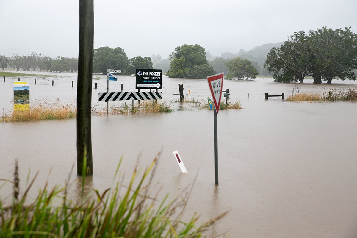
Heavy rain which may lead to flash flooding is forecast to redevelop over the northern rivers, north-eastern parts of the northern tablelands and northern parts of the mMid north coast forecast districts.
Widespread falls of 100 mm are forecast with local falls as high as 200 mm. The rain is expected to increase in intensity during the afternoon.
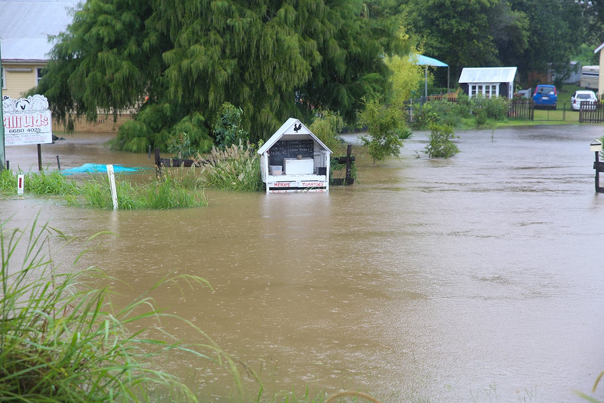
Flood warnings are current for the Tweed, Richmond, Brunswick and Wilsons river valleys.
Twenty-four-hour rainfall totals to 9am Saturday include 157mm at Couchy Creek, 141mm at Byron Bay and 122mm at Ballina.
Marcia, only the sixth recorded category five cyclone Australia has seen, made landfall in the largely uninhabited Shoalwater Bay on Friday morning.
It ‘grazed’ the regional town of Yeppoon, according to Weatherzone, and maintained a lot of its force to directly hit the city of Rockhampton as a category three.
Townships have been extensively damaged, with roofs ripped off homes, power lines down and trees uprooted.
Marcia was downgraded to a category one about 8pm on Friday and further downgraded to a tropical low about 1am.
Weatherzone reports that ‘despite packing gusts of over 200 kilometres there has been no loss of life throughout the disaster, but there have been a few near misses.


Flood warnings
As at midday Saturday a moderate flood warning had been issued for the Tweed Valley and a minor to moderate flood warning for the Wilsons and the Richmond. valleyls A minor flood warning had been issued for the Brunswick Valley.
The Wilsons River at Lismore is expected to reach 6.5 metres around 6pm this afternoon, with minor flooding.
The Richmond River at Coraki is expected to exceed minor flood level (3.4 metres) around midnight Saturday, with further rises expected.
The Tweed River is expected to reach moderate flood level (4.0 metres) at Murwillumbah around 4:00am Sunday morning and 1.4 metres on the high tide at Chinderah around 1:00pm today with minor flooding.
The Brunswick River is expected to reach minor flood level (2.5 metres) and Mullumbimby and Billinudgel this evening.
Road closures
Below is an update as of noon Saturday. Visit myroadinfo for upadates.
Baileys Bridge Road (near Summerland Way), Boatharbour Road, Bridge Street (North Lismore), Chelmsford Road (near Rock Valley Road),Clarence Way, Clothiers Creek Road, Coral Avenue (Mullumbimby), Crabbes Creek Road, Dalwood Road (Meerschaum Vale), Durhiem Road (Monaltrie), Deacon Street (Bangalow), Friday Hut Road (at Gittoes Land and Kirklands Crossing), Gradys Creek Road (gravel section), Grays Lane (Tyagarah), Houghlahans Creek Road causeways, Huonbrook Road, Left Bank Road, Marrom Creek Road at Gum Creek, Moleworth Street (Lismore, at Simes Bridge), Numinbah Road, Old Bangalow Road (Tintenbar), Old Tweed Road, Omagh Road (near Kyogle), Orion Street (Lismore, at Molesworth Street intersection), Palmwoods Road, Pearces Creek Hall Road (Pearces Creek), Piggabeen Road, Possum Shoot Road, Rowing Club Carpark (Lismore), Redgate Road (Sth Golden Beach), Sandy Creek Road (Kyogle), Sextonville Road, Stokers Road (north of school), Tickles Road (Coopers Creek), Tweed Coast Road North, Tyagarah Airfield, Wanganui Road, Whian Road (Eureka), Wilfred Street (Billinudgel), Wilsons Creek Road (Wilsons Creek), Wooyung Road, (Wooyung).
Earlier report:
The local meteorological group Northern Rivers Severe Weather has posted two scenarios for the track of the storm towards our region.
In the first she would be still a category 1 storm at the time she crossed the NSW border (expected to be early moring Saturday).
‘This should bring another surge of intense rainfall from mid- morning on Saturday, with 50-200mm falls possible depending on the positioning of the low and where it crosses the coast. Winds could be very intense and destructive at this stage, especially along the coast and adjacent elevated ranges as the system rapidly intensifies as it moves offshore,’ according to the group’s Facebook post this morning.

But a second scenario sees Marcia moving much slower, hugging the coastline and bringing very heavy rainfall to the region throughout Saturday into Sunday and even beyond.
Under this scenario, the group says, ‘the impact of the cyclone in terms of wind would be dramatically decreased, but result in a prolonged flood event for the Tweed, Brunswick, Richmond and Wilsons, Clarence and Orara, Bellinger and Nambucca Valleys’.
Communities are battening down ahead of the impending storm and almost all schools on the northern rivers have been closed for the day.
To make matters worse, forecasters are expecting the highest tides of the year along the coast, with rough seas and erosion likely.
Send your storm pics to [email protected]
The SES reports they have already received more than 30 calls, mostly from the catchment areas behind Murwillumbah and mostly to do with leaking roofs.
SES has five helicopters on standby for rescue and resupply.
Readers are advised to check before they travel at http://northernrivers.myroadinfo.com.au/ for local roads and https://www.livetraffic.com/ for major roads.
For emergency help call SES on 131 500.
If you are suffering from an emergency medical condition or require urgent rescue call 000.
Once again, the SES are imploring people not to cross flooded causeways, which is a leading cause of death in any flood.
A simple rule of thumb is that if water is above the hubcaps, it’s too dangerous to drive through.
 For four decades The Echo has printed the stories some people loved, some people hated, and some pretended not to read. If you want us to keep telling the truth, the real truth, not the sugar-coated version. We’ll need your support to keep the presses rolling.