Paul Bibby
While flipping through the draft concept plans for the Saltwater Creek affordable housing project, it’s hard not to feel a tickle of hope.
Depicted on the colourful pages are three small hamlets of ‘tiny homes’ clustered in a forest of melaleuca trees. Each group of 50 houses has its own village green, solar-powered shed and food garden, and the site as a whole has a number of shared working spaces, a medical centre and a cafe.
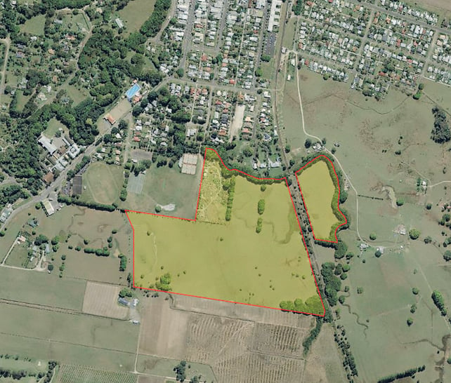
Located about ten minutes’ walk from the centre of Mullumbimby, the land is owned by Byron Shire Council, meaning that houses there could potentially be within reach of working locals if it remains in community hands.
Yet, even though the project is still in its infancy, it is already facing serious questions about whether it is an appropriate development.
A group of local residents has launched a campaign against the proposal, based on concerns about the flood-prone nature of the land and a lack of consultation.
They also say the proposal lacks adequate parking and would place extra pressure on already sagging local sewerage and road infrastructure.
In this respect, Salty Creek highlights the fundamental challenge faced by many affordable housing projects in the Byron Shire: the conflict between the need to build new houses to address the affordability crisis, and the need to minimise the impact on the local community.
The plan
The Saltwater Creek project was the outcome of a Council-sponsored search for land that could be used for affordable housing following last year’s housing summit.
The 22-hectare site, currently a little-used paddock behind the Mullumbimby community gardens, was identified through this process along with the much-discussed Saddle Road proposal.
Since then, a vision has begun to emerge through the work of Social Habitat, a group of local design, planning, building and community-development professionals.
Social Habitat is hoping to be centrally involved in making the project a reality down the track, but at this stage their role is that of volunteer consultants.
Social Habitat’s vision – currently little more than a handful of draft concepts – is for a community that is both environmentally and financially sustainable.
In addition to housing, the architects of Saltwater Creek envisage working spaces that would mean residents could live, work and grow food in the same place.
One of the founders of Social Habitat, Malcolm Price, says the group’s goal is for the future residents of Saltwater Creek to pay no more than 35 per cent of their income on housing. It is a lofty goal, given the soaring property market, but Mr Price believes Saltwater Creek has unique advantages that make this possible.
‘The biggest one is that the land is council owned,’ he says.
‘It means you don’t have private investors who have to sit there and pay interest on the loan they took out to buy the land while they’re waiting for planning approval.
‘Those holding costs are inevitably passed on [to buyers or renters].’
Unlike most private investors, Council is not purely driven by a profit motive.
The Echo understands that Council is hoping to get a reasonable annual return from the project, but may also be willing to limit the size of that return in order to achieve the ‘social dividend’ of affordable housing.
Mr Price says that the cost of housing at Saltwater Creek would also be kept low through the use of ‘tiny’ or ‘manufactured’ homes.
‘Not only are the houses themselves cheaper to build, but they take up less space so less money needs to be spent on infrastructure,’ he says.
‘We think the cost of infrastructure for this project could be kept quite low.’
The first step in the process of turning the swampy paddock next to Saltwater Creek into an affordable-housing village is rezoning it from recreational open space to general residential.
Late last year the council applied to the NSW Department of Planning to amend its Local Environment Plan so that this could occur. Council has developed a timetable that would see the project reach the final planning stage in October.
Residents left out
For a group of nearby residents, this timetable has simply added to the feeling that Council is forging ahead with a deeply flawed plan with little or no consultation.
Karl Allen lives with his wife on Fern Street, Mullumbimby, and says he and others feel they have been completely left out of the process.
‘We really feel that the council has decided to go ahead with this and that it’s virtually a fait accompli,’ Mr Allen says.
And if – and when – a proposal does go on public exhibition, flooding will be a common theme among residents’ concerns.
During major rain events such as the powerful deluge in March last year, large parts of the land were under water along with other surrounding areas.
Mr Allen and his wife, who live to the north of the proposed site, had about 35cm of water lapping at their garage door.
The development proposal involves filling parts of the field with soil to keep the houses above the floodline.
But residents say this would shift the water off the site and into surrounding areas, including the streets where they live.
‘I’ve already experienced an increase in the amount of water coming onto my property as a result of the house built on fill behind my place,’ Mr Allen says.
‘I hate to think what would happen if they go ahead and build this development and we have another flood like last year. It wouldn’t just be a disaster for us, it would be a disaster for the people living there as well.’
Contested report
But Council’s flood assessment report for the site offers a different view.
Produced by private consultants BMT WBM, the report states that, through the use of carefully designed drainage reserves and judicious use of fill, the risk can be significantly ameliorated.
‘This assessment suggests that in terms of impact on peak flood levels for the flooding events simulated, a feasible development may be achieved,’ the BMT report states.
But residents say this assessment is seriously flawed.
They say they have identified 15 errors or failings in the report, including relying on the earlier, inaccurate North Byron Shire Flood Study.
The report also does not include the combined effects of catchment rainfall and a tidal storm surge, and that it seems to ignore the fact that during flood events Saltwater Creek sometimes flows in a west-to-east direction.
The credibility of reports that underpin Council’s decision-making is well known to Bangalow residents, who recently rejected paid parking based on what was later admitted to be a flawed report.
But the BMT WBM report does acknowledge that a ‘more detailed flooding assessment will be needed to confirm that the proposed development does not cause adverse impacts to neighbouring property prior to seeking development approval’.
Yet this does not engender a sense of relief among residents, such as Stephen Bellerby of Station Street.
‘We want the rezoning process to at least be put on hold until the council’s Floodplain Risk Management Strategy has been completed in 2019,’ Mr Bellerby says.
Council response
Council’s director of Sustainable Environment and Economy, Shannon Burt, says the decision to apply to the department to rezone the land is the result of ‘the demand from the community for Council to look at providing a diversity of housing options for residents.’
‘Our community is constantly telling Council that housing affordability and diversity is an enormous problem and it is looking to this organisation to provide opportunities for people to provide housing options for people on a range of incomes and also to suit their needs according to the time of their life,’ Ms Burt says.
‘Council has not yet engaged in community consultation on the planning proposal for the land in Stuart Street because we need to know first if this will be approved by the NSW government, and receive a gateway determination to do so,’ she says.
 For four decades The Echo has printed the stories some people loved, some people hated, and some pretended not to read. If you want us to keep telling the truth, the real truth, not the sugar-coated version. We’ll need your support to keep the presses rolling.