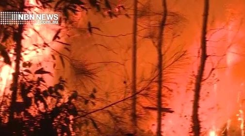
Of four bushfires burning in the Northern Rivers since the weekend, just one has been contained.
Two others continue to rage out of control, each having burnt out thousands of hectares.
And because of the cold weather, the Rural Fire Service (RFS) says smoke is trapped at low levels, causing potentially hazardous levels of smoke in some areas.
Ellangowan fire
One fire at Mothersoles Road, Ellangowan, 17 kilometres south-east of Casino, has burnt 3,047 hectares.
The fire remains out of control, according to the latest RFS report, despite earlier advice that it was ‘being controlled’.
The RFS has been working on strengthening and consolidating containment lines and says the immediate threat to properties has reduced overnight.
But the fire service adds, ‘Winds are forecast to strengthen today, which could see gusts of 30-40kph across the fireground.’
Buccarumbi fire
A fire burning in the vicinity of Old Glen Innes Road, Buccarumbi, about 30km south-west of Grafton, has burnt 1,582 hectares and is out of control.
The fire is burning in a north-easterly direction along Old Glen Innes Road. Firefighters are working to protect isolated properties near Setters Road, Weasel Road, Doboy Road and Glens Creek Road.
Firefighters are in attendance and are working with local residents. Waterbombing aircraft have been assisting firefighters on the ground.
As conditions allow, backburning operations will be undertaken by firefighters to build and consolidate containment lines. This will result in an increase in fire activity and smoke in the area.
Old Glen Innes Road is closed at the Doboy Road intersection.
Kippenduff fire
A fire burning in the Brewers Road, Kippenduff area, about 35km south-west of Casino, has burnt 255 hectares and is out of control.
This fire continues to burn in a west to north-westerly direction towards a number of isolated rural properties.
Firefighters remain on scene and continue to work on strengthening and consolidating containment lines overnight.
Winds are forecast to strengthen again tomorrow, which could see gusts of 30-40kph across the fireground.
Smiths Creek fire
The fourth fire is burning near Coal Ridge, Smiths Creek, about 30km north-west of Grafton, into the Wombat Creek Conservation Area. The fire has burnt 616 hectares and is being controlled.
Firefighters, assisted by heavy machinery, remain on scene and continue to work on strengthening and consolidating containment lines.
The immediate threat to properties has reduced.
Watch and act
The RFS advice for people living near any of these fires is to:
- Monitor conditions in your area.
- Check and follow your Bush Fire Survival Plan.
- If you do not have a plan, decide what you will do if the situation changes. Leaving early is your safest option.
- Follow the directions of firefighters on the ground.
- If your life is at risk, call Triple Zero (000) immediately.
- Continue to stay up to date with the bush fire situation by checking the RFS website, listening to your local radio station or by calling the NSW RFS Bush Fire Information Line on 1800 679 737.
- For information on road closures, check the LiveTraffic website. Roads may be closed without warning
 For four decades The Echo has printed the stories some people loved, some people hated, and some pretended not to read. If you want us to keep telling the truth, the real truth, not the sugar-coated version. We’ll need your support to keep the presses rolling.