Update: Tuesday, 19 November 2019, 8am
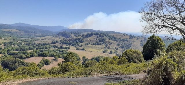
Mt Nardi Fire
The fire is more than 6,200 hectares in size and is not yet controlled.
Current Situation
- The fire is burning in the Nightcap National Park area, east of Nimbin.
- Increased fire activity has been reported around the Doon Doon, Commissioner’s Creek, Whian Whian and Nightcap Range Road.
- Back burns were carried out around the Commissioners Creek, Doon Doon and Repentance Creek areas today. Crews will continue to consolidate containment lines in these areas overnight.
- The fire is expected to burn for several weeks or until there is significant rainfall. During this time, the fire may burn close to properties.
Advice
- If you are in the area of Doon Doon, Commissioner’s Creek, Mt. Burrell and Rolands Creek areas, monitor conditions.
- If you are in the areas of Tuntable Creek, Huonbrook Valley, Upper Wilsons Creek, Commissioners Creek and Upper Coopers Creek, monitor conditions.
- Know what you will do if the fire threatens.
Wardell Fire
The Wardell fire has burned 891ha and is now classified as ‘under control’.
Myall Creek, Bora Ridge Fire
The fire is more than 17,090 hectares and is out of control.
Current Situation
- There was an increase of activity in the area of Main Camp Road yesterday.
- The fire is burning in the area of west of the Pacific Highway, north of the Clarence River and east of the Summerland Way.
- The fire is burning towards the Main Camp Road area, Elliots Road and the Tullymorgan-Jackybulbin Rd areas.
- The southern edge of the fire is continuing to burn through the Doubleduke State Forest towards the Tabbimobile State Forest.
- The fire may cross the Pacific Highway later today then burn towards the Woombah and Iluka areas.
Advice
- The fire may reach the Pacific highway today, it may be closed at short notice. Stay up to date with Live Traffic NSW.
- Residents on the eastern side of the highway in the vicinity of Woombah and Iluka should monitor conditions and know what to do if a fire approaches.
- If you are in the area Bungawalbin, New Italy, Gibbragee and Tullumorgan, monitor conditions and know what to do if a fire approaches. Take advice from firefighters in the area.
- If you are in the area of Swan Bay, Tabbimobile and Woombah, monitor conditions.
Essential Energy bushfire update – Restoration efforts continue
More than 300 Essential Energy personnel on the ground continued to work through the weekend, replacing power poles destroyed by the fires still burning across the north coast. Power was restored to further homes and businesses throughout the region, with a total of 415 power poles being replaced so far – 75% of the 565 identified as destroyed in last week’s bushfires.
As at 6pm, Monday 18 November, 600 bushfire affected customers are without power.
Conditions permitting, power will be restored progressively throughout this week, with majority of homes and businesses having the lights back on by the next weekend. The safety of our people and the surrounding homes and businesses remains our main priority.
Coffs Harbour LGA
With 35 power poles being replaced in the area, only 9 customers in the Glenreagh area are without supply.
Clarence Valley LGA
Crews have progressed well with around 130 poles replaced to date and majority of homes and businesses having had their restored across the Clarence Valley.
Byron Bay LGA and Richmond LGA
Just over 20 customers are without power in New Italy, Bora Ridge and surrounding areas as our crews await safe access to the electricity network.
A reminder: stay more than 8 metres away from fallen or damaged powerlines and report to Essential Energy on 13 20 80.
————————————————
Update: Saturday, 15 November 2019, 7.30pm
Mt Nardi Fire
There is an increase in fire activity on the northern side of the fire, in the Commissioners Creek area. Firefighters are working on strategic backburns, and are identifying containment lines. Crews are working to protect properties as the fire comes from ridge lines.
If you are in the areas of Tuntable Creek, Huonbrook Valley, Upper Wilsons Creek, Commissioners Creek and Upper Coopers Creek, monitor conditions.
Myall Creek, Bora Ridge Fire
The Myall Creek fire continues to burn out of control. Status remains the same as the 2.30pm update.
Update: 2.30pm
Mt Nardi Fire
The Mount Nardi fire in the Nightcap National Park between Nimbin, Repentance Creek, Mullumbimby and Doon Doon continues to burn out of control. Firefighters are working on strategic backburns, and are identifying containment lines. Crews are working to protect properties as the fire comes from ridge lines.
If you are in the areas of Tuntable Creek, Huonbrook Valley, Upper Wilsons Creek, Commissioners Creek and Upper Coopers Creek, monitor conditions.
Myall Creek, Bora Ridge Fire
The Myall Creek fire is more than 10,300 hectares and remains out of control. The fire in burning in the area of Bungawalbin and New Italy
The fire is burning towards the Main Camp Rd area. The southern edge of the fire is continuing to burn through the Doubleduke State Forest towards the Sandy Crossing area.
The Pacific Highway is open, but visibility may be reduced due to smoke. Stay up to date with Live Traffic NSW.
Leave now if you are in the area of Gibberagee and the path is clear, leave now towards Summerland Way.
If you are in the area of Whiporie, watch out for smoke and embers.
If you are in the area Neileys Lagoon, Bungawalbin-Whiporie and Williams Road, Whites Road and New Italy, monitor conditions and know what to do if a fire approaches. Take advice from firefighters in the area.
If you are in the area of Hallwoods Road, watch out for burning embers which may start spot fires ahead of the main fire front.
If you are in the area of Boggy Creek Road, Eucalyptus Drive, Swan Bay and east of the Pacific Highway near Turners Road and Red Gate Road, monitor conditions.
Update: Friday, 15 November 2019, 1.30pm
Mt Nardi Fire
Origin are currently working to restore power to Wanganui Road.
Myall Creek, Bora Ridge Fire
The fire in burning in the area of Bungawalbin and New Italy. The southern edge of the fire is continuing to burn through the Doubleduke State Forest towards the Sandy Crossing area.
The fire is expected to cross the Bungawalbin Whiporie Road today. Crews are working in the Neileys Lagoon Road, Bungawalbin Whiporie Road and Williams Road areas working to protect property if required.
The Pacific Highway is open, but visibility may be reduced due to smoke. Stay up to date with Live Traffic NSW.
If you are in the area Neileys Lagoon, Bungawalbin Whiporie and Williams Road, Whites Road and New Italy, monitor conditions and know what to do if a fire approaches. Take advice from firefighters in the area.
If you are in the area of Hallwoods Road, watch out for burning embers which may start spot fires ahead of the main fire front.
If you are in the area of Boggy Creek Road, Eucalyptus Drive, Swan Bay and east of the Pacific Highway near Turners Road and Red Gate Road, monitor conditions.
Update: 11.30am
Mt Nardi Fire
With over 4,900ha burnt out the Mt Nardi fire remains out of control.
Rural Fire Service (RFS) firefighters have retained the line at Mop’s track overnight. The Western/Tuntable side of Wallace Road fire has also held at Siddha Farm overnight according to local Terri Nicholson on her Facebook page.
Properties in Upper Wilsons Creek that have also been defended by the RFS.
Wanganui, Huonbrook, all of Wilsons Creek, Main Arm, Palmwoods, Goonengerry and areas bordering the national park need to remain alert to changes in the fire conditions.
The advice is to get done what you have to do and be ready for Saturday which is predicted to be very hot
Wardell Fire
The Wardell fire is now classified as ‘under control’.
Myall Creek, Bora Ridge Fire
Alert level remains Watch and Act.
The fire in burning in the area of Bungawalbin and New Italy. Fire activity eased overnight and the immediate threat to properties has lowered although conditions are forecast to worsen later today.
Northerly easterly winds are pushing the fire south westerly towards Bungawalbin and Doubleduke State Forest areas.
Crews are working in the Neileys Lagoon Road, Bungawalbin Whiporie Road and Williams Road areas working to protect property if required.
The Pacific Highway is open, but visibility may be reduced due to smoke. Stay up to date with Live Traffic NSW.
Essential Energy bushfire update – Thursday, 14 November –9.30pm
Essential Energy crews have continued restoration work throughout today, replacing power poles, repairing electricity infrastructure and gaining access to areas that have been inaccessible until now.
More than 400 employees are working across the North Coast, in liaison with the RFS and local Emergency Operating Centres, to safely make repairs and assess damage to the network.
Access continues to be our biggest challenge with burnt out and smouldering trees blocking tracks and smoke preventing helicopters flying in some areas over the network. Drones are being used where possible, allowing planning to be undertaken in preparation for when access does become available.
Restoration efforts have been ongoing today with crews restoring power to some customers in the Clarence, Nambucca and Macleay Valley areas. 2,100 customers are currently without power.
In many areas power may not be restored to customers for a number of days or up to a week. We are in the process of confirming these areas to provide estimated times of restoration to customers.
To date, repairs have included the use of almost 42,000 items of equipment, 120+ cross arms, 31 transformers with power pole replacements ongoing.
Following is an update of response efforts for each local government area:
Coffs Harbour LGA
50 customers are without power in the Coffs Valley with access becoming possible today into the fire affected areas west of Coffs Harbour.
22 power poles have been confirmed as needing replacement with this number likely to rise as work continues.
A helicopter will perform aerial patrols once safe to fly – the smoke is hampering these patrols.
Clarence Valley LGA
250 customers are without power across the Clarence Valley.
More than 170 power poles were destroyed during the fires, with 38 of these having been replaced.
Over 100 crew members are on the ground making repairs with power restored to Blaxlands Creek and Blaxlands Flat, with it hoped to have Nymboida Village on late this evening – conditions permitting.
We don’t currently have an estimated time of power restoration for customers in the kangaroo Creek and Glenns Creek areas.
Byron Bay LGA and Richmond LGA
Some customers in the Huonbrook, Mullumbimby, New Italy, Coraki and Wanganui areas are without power following fires yesterday.
Our crews have not been able to safely undertake repairs and are working closely with the Rural Fire Service.
Estimated restoration times will be available on the outage page of Essential Energy’s website at www.essentialenergy.com.au once known. We apologise we are unable to provide further details at this time however our crews continue to be committed to restoring power as quickly as safety will allow.
———————————————————————-
Update: Thursday, 14 November 2019, 8.30pm
Myall Creek, Bora Ridge Fire
The current fire alert is Emergency Waring. If you are in the area Neileys Lagoon and Yellow Crossing, shelter as the fire approaches. Protect yourself from the heat of the fire.
If you are in the area of Williams Road, Whites Road and New Italy, know what to do if a fire approaches.
If you are in the area of Mahogany Road and Forest Road, watch out for burning embers which may start spot fires ahead of the main fire front.
If you are in the area of Boggy Creek Road, Eucalyptus Drive and Swan Bay, monitor conditions.
———————————————————————–
Update: Thursday, 14 November 2019, 6pm
A Total Fire Ban has been declared for the Far North Coast, North Coast, Greater Hunter, Greater Sydney Region, Illawarra/Shoalhaven, Central Ranges, New England, and Northern Slopes regions tomorrow, Friday 15 November 2019, due to forecast hot and windy conditions.
The Total Fire Ban, commencing at midnight tonight, covers the following councils:
Far North Coast (Severe) — Ballina, Byron, Clarence Valley, Kyogle, Lismore, Richmond Valley, Tweed
North Coast (Severe) — Bellingen, Coffs Harbour, Port Macquarie-Hastings, Kempsey, Nambucca, Mid-Coast
Greater Hunter (Severe) — Cessnock, Dungog, Lake Macquarie, Maitland, Muswellbrook, Newcastle, Port Stephens, Singleton, Upper Hunter
Greater Sydney Region (Severe) — including the Blue Mountains and Central Coast
Illawarra/Shoalhaven (Severe) — Kiama, Shellharbour, Shoalhaven, Wingecarribee, Wollondilly, Wollongong
Central Ranges (Very High) — Bathurst, Blayney, Cabonne, Cowra, Lithgow, Mid-Western, Oberon, Orange
New England (Very High) — Glen Innes Severn, Tenterfield, Uralla, Walcha, Armidale
Northern Slopes (Very High) — Gunnedah, Gwydir, Inverell, Liverpool Plains, Tamworth
The NSW Rural Fire Service (NSW RFS) provides the following advice:
Under Severe and Very High fire conditions:
Well prepared homes that are actively defended can provide safety during a fire.
Follow your Bush Fire Survival Plan and remain vigilant.
Keep informed by listening to local radio, watching television news broadcasts and monitoring www.rfs.nsw.gov.au.
Please note: The NSW RFS may issue a Harvest Safety Alert for areas of heightened risk. Harvest operators should monitor conditions and regularly check that they are operating within guidelines.
No fires may be lit in the open and all fire permits are suspended during a Total Fire Ban. Gas and electric barbeques may be used provided certain conditions are met. Total Fire Ban rules and a map of current Total Fire Ban areas are listed at www.rfs.nsw.gov.au.
———————————————————————
Update: Thursday, 14 November 2019, 4pm
Myall Creek, Bora Ridge Fire
The fire alert has increased from Watch and Act to Emergency Warning. Currently the fire in burning in the area of Bungawalbin and Yellow Creek. Northerly winds are pushing the fire south towards New Italy, Donaldson, and Doubleduke State Forest.
The Pacific Highway is open, but visibility may be reduced due to smoke. Stay up to date with Live Traffic NSW.
If you are in the area Neileys Lagoon and Yellow Crossing, shelter as the fire approaches. Protect yourself from the heat of the fire.
If you are in the area of Williams Road, Whites Road and New Italy, know what to do if a fire approaches.
If you are in the area of Mahogany Road and Forest Road, watch out for burning embers which may start spot fires ahead of the main fire front.
If you are in the area of Boggy Creek Road, Eucalyptus Drive and Swan Bay, monitor conditions.
Mt Nardi and Wardell Fire
Both these fires remain at the Advice level with conditions remaining stable at the moment.
———————————————————————
Update: Thursday, 14 November 2019, 12.30pm
Myall Creek, Bora Ridge Fire
The fire is currently burning in the area of Williams Road, Bungawalbin–Whipore Road and Whites Lane. Crews are working on containing the fire to the west of the highway south of Woodburn.
The northerly winds will push the fire south towards the New Italy, Donaldson, and Doubleduke State Forest.
The Pacific Highway is open, but visibility may be reduced due to smoke. Stay up to date with Live Traffic NSW.
If you are in the area of Williams Road, Bungawalbin–Whipore Road, Whites Road, Moonem New Italy Road and the area of New Italy, know what to do if a fire approaches.
If you are in the area of Boggy Creek Road, Eucalyptus Drive and Swan Bay, monitor conditions.
Watch out for burning embers which may start spot fires ahead of the main fire front.
Mt Nardi Fire
Conditions eased overnight for the fire burning in the Mount Nardi area, Nightcap National Park between Nimbin, Repentance Creek, Mullumbimby and Doon Doon.
There are some current flare ups around Wanganui and firefighters are working to protect properties and establish containment lines.
If you are in the areas of Tuntable Creek, Huonbrook Valley, Upper Wilsons Creek, Commissioners Creek and Upper Coopers Creek, monitor conditions.
Update: Important public information regarding NSW bush fires
Thursday, 14 November 2019, 7am
The RFS say that fire activity remained relatively consistent yesterday which allowed firefighters to identify containment lines as there is still a large amount of fire burning in the northern part of the state.
There are still 68 active fires burning throughout the state – 20 between Coffs Harbour and Tweed Heads – none are at emergency warning level and eight are at watch and act level. See Fires Near Me.
The Mt Nardi NP fire details were updated by the RFS at 1.52am today – the alert left is a code blue:
Advice – if you are in the areas of Tuntable Creek, Huonbrook Valley, Upper Wilsons Creek, Commissioners Creek and Upper Coopers Creek, monitor conditions and know what you will do if the fire approaches.
While conditions have eased the RFS expects a return to warmer fire conditions towards the end of the week and mid next week. They urge residents to keep up to date on fire activity in their area.
Please refer below to important details of the whole-of-government information for the people of New South Wales in response to the on-going bush fire activity in the state. Please share the information below with family and friends.
———————————————————
Myall Creek, Bora Ridge Fire – Public Meeting: November 14, 11am
A community meeting will be held tomorrow (Thursday November 14) to update residents on the current bushfire situation. It will be held at Woodburn Bowling Club – 106 Richmond St, Woodburn – at 11am. Representatives from the NSW Rural Fire Service, NSW Police and Council will be available to provide information and advice.
Update: Important public information regarding NSW bush fires
Wednesday, 13 November 2019, 12.00pm (midday)
Source: RFS
The fire burning near Mount Nardi in Nightcap National Parl is over 3,347ha in size.
Firefighters have been working to protect important communications infrastructure and dwelling in the area around Tuntable Creek, Huonbrook and Upper Wilsons Creek as well as the villages of Doon Doon, Main Arm, Mdginbil, Kunghur Creek, Palmwoods and Commissioners Creek.
Very high fire danger is predicted today with gusty east-south-easterly to south-easterly winds expected. This may push the fire north/north westerly towards Doon Doon, Main Arm, Upper Main Arm, Midginbil, Kunghur Creek and Palmwoods as well as the areas of Tuntable Creek, Whian Whian, Dorroughby, Goonengerry, Huonbrook, Upper Wilsons Creek, Wilsons Creek and Upper Coopers Creek.
Update: Important public information regarding NSW bush fires
Wednesday, 13 November 2019, 6.45am
The New South Wales Police Force and New South Wales Rural Fire Service wish to thank the community for taking warnings seriously and taking action during yesterday’s dangerous bush fire conditions.
While conditions have eased, there is a large number of fires still burning throughout the State and residents are urged to stay up to date on fires in their area.
The following message details important, whole-of-government information for the people of New South Wales in response to the on-going bush fire activity in the State. Please share the information below with family and friends.
Rural Fire Service
A Total Fire Ban remains in place for the whole of the state.
Stay up to date on fires in your area. People are urged to download the ‘Fires Near Me’ app: https://www.rfs.nsw.gov.au/
If you are threatened by fire, you need to take action to protect yourself. Do not be caught in the open.
Keep up-to-date with major fire updates: https://www.rfs.nsw.gov.au/
For more information about the fires, contact the Bush Fire Information Line – 1800 679 737
Transport
- All XPT services will be suspended until Wednesday evening.
- Sydney to Brisbane service cancelled today.
- No Freight services running today
- Express coaches will continue to operate from Casino to Wauchope (subject to road closures)
- Brisbane service not running today
- Passenger shuttle between Casino and Wauchope
- Latest information on public transport – www.transportnsw.info or call 131 500
Welfare (Evacuation Centres)
We encourage all people in and around fire affected areas to register online with the Red Cross operated Register Find Reunite site at https://register.redcross.org.
Coffs Harbour
– Urunga Ex Servicemans Club – 2 Morgo St, Urunga
– Woolgoolga Ex Servicemans Club – 17 Beach St, Woolgoolga
– Coffs Harbour Ex Servicemans Club – 2 – 6 Vernon St, Coffs Harbour
Clarence Valley
– Grafton Community Centre – 59 Duke St Grafton NSW 2460
Lismore
– Nimbin Showground – 33-37 Cecil St, Nimbin NSW 2480
– Mullumbimby Ex Services – 58 Dalley St, Mullumbimby NSW 2482
– Goonellabah Sports & Aquatic Centre – 50 Oliver Ave, Goonellabah NSW 2480
– Cavanbah Centre Byron Bay – 249 Ewingsdale Rd, Byron Bay NSW 2481
– Coraki Bowling Club
Update: 8.40pm, Tuesday 12 November
Current conditions for the Mount Nardi fire are easing across the fireground according to RFS.
- If you are in the area of Tuntable Falls, Terania Creek Road and Terania Creek, monitor conditions.
- Tuntable Falls Road is closed east of Nimbin and other local roads.
Update: 4.30pm
The following areas in the Byron Shire are now being door knocked for evacuation – Main Arm, Palm Woods, Huonbrook, Wanganui, and Wilsons Creek. Residents and property owners will be reminded that it is a good time to leave if they are not staying to defend.
Fire crews are currently active in Huonbrook and Wanganui and Upper Wilsons Creek.
The RFS has issued the following advice for people in Evan’s Head and Woodburn: ‘if your plan is to leave – leave now in a northerly direction towards Lismore via the Pacific Highway and Ballina. An evacuation centre is open at the Goonellabah Sports and Aquatic Centre – 50 Oliver Avenue, Goonellabah’
Update 3.30pm
Wilsons Creek is now being told by highway patrols to evacuate. Residents and property owners will be reminded that it is a good time to leave if they are not staying to defend.
Update 1.30pm
This is the latest from the RFS on the Mount Nardi National Park fire
Current Situation – watch and act
A fire is burning in the Mount Nardi National Park. Conditions are easing across the fireground.
The fire is not yet contained. The immediate threat to homes has eased.
The fire is burning on multiple fronts towards Tuntable Falls Road in the south, and Huonbrook in the east.
Advice
If you are in the area of Tuntable Falls, Terania Creek Road and Terania Creek, monitor conditions.
Check and follow your Bush Fire Survival Plan. If you do not have a plan, decide what you will do if the situation changes. Leaving early is your safest option.
Rummery Park campground is closed.
Update: 10am
The fire area at Mount Nardi in the Nightcap National Park has now expanded to 2600ha in size.
Severe fire danger is predicted for the Northern Rivers region today say the Rural Fire Service (RFS). They are predicting gusty north westerly winds are expected to push the fire south towards the areas of Tuntable Creek, Terania Creek, Whain Whain, Dorroughby, Goonengerry, Huonbrook, Upper Wilsons Creek, Wilsons Creek, Upper Coopers Creek and surrounding areas.
‘Under predicted fire conditions the fire will move quickly and roads may be closed without notice. Do not expect a fire truck at your property,’ said the RFS in a recent statement.
Communication outages
While the fire services are doing everything they can to protect the communication towers on Mount Nardi they have warned that there may be communications outages as a result of the fire.
For information on road closures call NSW RTA on 131 700 or visit www.rta.nsw.gov.au.
For information on National Parks.
Stay up to date by listening to your local radio station or call the NSW RFS Bush Fire Information Line on 1800 679 737 or monitor Fires Near Me.
Update: 9am
Donations
The Mullumbimby and District Neighbourhood Centre (MDNC) is now accepting online donations via its website and can also accept gift vouchers. There are no administration or handling fees providing assurance that every cent of money/vouchers donated will be passed on to people in the community who are in need of help. Currently the CWA and Mullumbimby Ex-Services Club are no longer taking.
School closures
Some schools will be closed tomorrow including Upper Main Arm School, Dunoon Public School, Nimbin Central School, The Channon Public School, Upper Coopers Creek Public School, Whian Whian Public School. People should check with their local schools – details can be found on the NSW department of education website.
Evacuating animals
People needing help with companion animals should contact the Mullumbimby and District Neighbourhood Centre on 6684 1286 or they can be taken to the Cavanbah Centre.
Original story: November 11
Over 1,000 people turned up for the community fire meeting at the Civic Hall in Mullumbimby this morning. The hall was full with rows of people at every door as concerned locals strained to hear the fire services, police, council and other emergency services groups spell out the current fire risks for the Byron Shire and beyond.
The message was clear, prepare your properties as this makes the job if defending it much easier and be clear regarding your fire plan. If you are going to stay and defend your properties then make sure you prepared. If you are going to leave leave early.
The emergency services are expecting the wind change tomorrow to potentially send the fire down the valleys on the Byron Shire side of the mountain.
Key areas of concern
The key areas that they are concerned about are those areas that border onto the state forest and national parks.
The two worst areas they expect to be affected are Mill Road, Goonengerry and Koonyum Range closely followed by Huonbrook, Wanganui, all of Wilsons Creek, Main Arm, Coopers Lane, and Upper Coopers Creek Road.
The point was reiterated that areas like Wilsons Creek that have narrow, hazardous, single route access and will be vulnerable to being blocked off by fire.
‘Tomorrow is a good day to go shopping,’ said RFS deputy captain, Bob Graham.
Brian Daley Region, North operations manager superintendent said, ‘There is burning rainforest and I believe that there has been no fire like this since 1964.’
There will be fire danger throughout NSW from severe and extreme to catastrophic.
‘I don’t know if we have had this level of fire rating in NSW before,’ said superintendent Daley.
Property and infrastructure protection
Once the wind gets up they will be focussed on property and infrastructure protection. They made it clear that they would not always be able to get fire trucks to every property.
‘There are never enough fire trucks to be at every house,’ said superintendent Daley. ‘Be prepared and make decisions early and stay up to date.
‘Decide if your house is defensible and if your not comfortable staying to defend then leave early for a place that is safe. We can replace houses but not people.’
Decisions on what properties can or will be protected are made on the ground as fire conditions change. The lives and safety of the fire crews will be a key consideration in those decision.
Keep up to date
The key sites to check are Fires Near Me, the RFS Major Fires Update page and Follow RFS on Facebook which will be updated as conditions change. You can also check your local council website and Facebook pages for more information.
This page will continue to be updated as more information comes in.
Evacuation Centres
Evacuation centres are being set up from 2pm today (Monday, 11 November) at The Mullumbimby Ex-Services Club on Dalley Street in Mullumbimby and at the Cavanbah Centre on Ewingsdale Road, Byron Bay.
They are also available at Southern Cross University, Military Road, East Lismore and the Nimbin Showground.
Please register at an Evacuation Centre before finding alternative accommodation or register online.
Anyone in the bushfire-affected areas are urged to let their loved ones know they’re ok by registering online with the Red Cross’s Register Find Reunite website. This will also assist the RFS and other emergency services to know if you are at the property or not.
For websites and telephone numbers go to Council’s bushfire website.
Medical services
Mullumbimby Medical Centre on Stuart Street in Mullumbimby has said that they will accept anyone who needs medical assistance or has been impacted by fire for emergency appointments.
If you need hospital treatment go directly to the nearest hospital or call an ambulance on 000.
 For four decades The Echo has printed the stories some people loved, some people hated, and some pretended not to read. If you want us to keep telling the truth, the real truth, not the sugar-coated version. We’ll need your support to keep the presses rolling.