An East Coast Low off the south-east Queensland coast is expected to bring an increase in winds, surf and rain to northern New South Wales from Friday and impact southern Queensland from Wednesday say the Bureau of Meteorology (BOM).
The BOM will continue to monitor the low over the coming days and stated that, ‘The strength of the wind and waves will be highly dependent on the strength and position of the low relative to the coast’.
The heaviest falls of rain are expected to fall offshore and while the soils of the region remain wet the rain is not expected to cause widespread riverine flooding.
‘Some localised creek and river level rises are possible. The requirement for a Flood Watch will be reviewed each day,’ said the BOM in their statement.
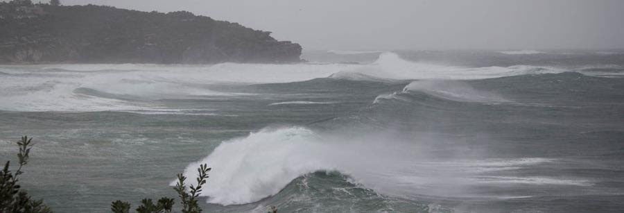
Strong winds and large seas
Strong winds from the Queensland coast will extend into New South Wales from Thursday.
‘The wind is expected to increase further, particularly from Friday, as the low deepens. There is a risk of damaging wind gusts of more than 90km/h on Friday and early Saturday around the exposed coastal fringes of firstly southern Queensland, then northern New South Wales,’ state the BOM.

Coastal erosion
‘A hazardous east to south-easterly swell is also expected to develop along the southern Queensland and northern New South Wales coast on Friday and persist over the weekend as an East Coast Low develops in the Coral Sea well offshore of the south-eastern Queensland coast and moves away eastward.
‘The swell may lead to coastal erosion in vulnerable areas along the southern Queensland and northern New South Wales coasts.’
Weather warnings for damaging winds and damaging surf may be issued for southern Queensland and northern New South Wales later in the week.
Communities are encouraged to keep up to date with the latest forecasts and warnings through the Bureau’s website and BOM Weather app and follow the advice of emergency services.
 For four decades The Echo has printed the stories some people loved, some people hated, and some pretended not to read. If you want us to keep telling the truth, the real truth, not the sugar-coated version. We’ll need your support to keep the presses rolling.