Photo Mullum Residents Association social media page
A proposal by a landowner and Council staff to mitigate flooding and enable development on large floodplain lots on 75 New City Road has been roundly criticised by Council’s Floodplain Committee members and residents as not only unworkable, but a danger to life should it be approved.
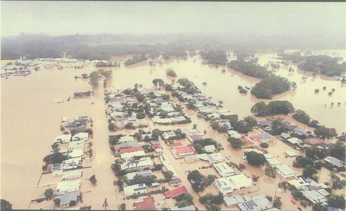
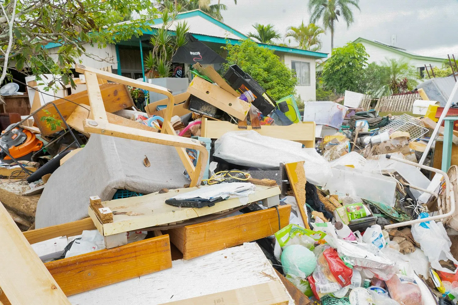
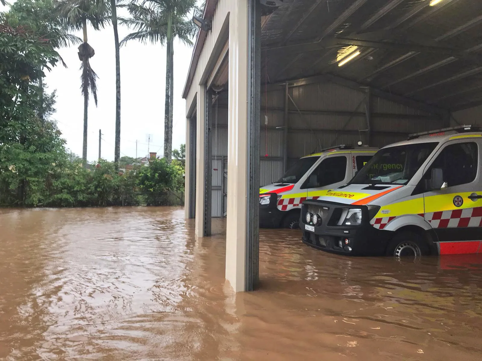
This week marks the second anniversary of the devastating floods – many residents in the region are still coping with the impacts of the 2022 flood, and are without promised government funding.
Large floodplain lots at 75 New City Road and 1B Ann Street were included in Council’s Housing Options Paper last year, without public consultation. Mayor Michael Lyon’s successful motion just got over the line with support from Crs Mark Swivel, Asren Pugh, Peter Westheimer and Alan Hunter.
The Options Paper was roundly criticised by community groups for a myriad of reasons, and ‘underpins’ Council’s Residential Strategy 2024, which could be adopted at the upcoming meeting on March 14.

Residential Strategy 2024 up for adoption
Council staff are asking councillors to adopt the entire strategy at that meeting – without any further public consultation – but with their recommended inclusions and exclusions of lands. The large rural Mullum land lots are included.
Remarkably, staff base their argument in part on pre-2022 flood data, while also admitting it needs updating.
On page 21 of the March 14 Council agenda, Shannon Burt, Director Sustainable Environment and Economy, writes, ‘Detailed flood and stormwater management investigations must be undertaken concurrently as part of a single “combined” planning proposal’.
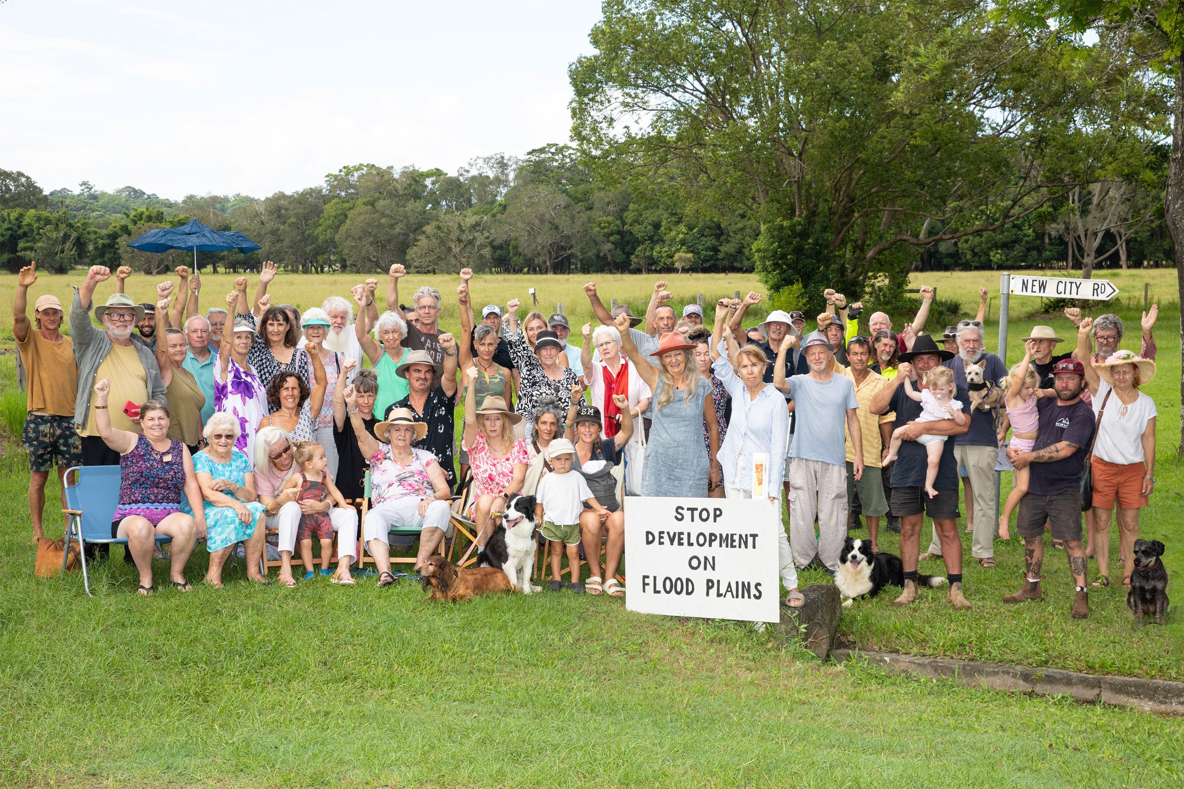
Mobilised residents
A well-organised community campaign against the proposal is underway, and the mayor will face residents in a Zoom meeting over the strategy on March 11 from 6pm–8pm (see page 2 ad).
The landowner of 75 New City Road, Frea Bandini, told The Echo that she and Council have been working on plans to mitigate flooding and propose to build large mitigation ponds and erect stormwater gates at Kings Creek.
She told The Echo she had to sign a non-disclosure agreement with Council for the flooding report she helped pay for.
‘All of Council’s drains lead onto my property via big open culverts’, she said,
‘And because the water can’t escape, it’s got nowhere to go. Over the years it became worse’, she says, ‘because of secondary dwellings, etc which I’m completely fine about – we need housing’.
Ms Bandini says, ‘Flood studies prove that stormwater, not floodwater, affects my property. Flood water that comes to my farm is not from Kings Creek, but comes across town during a major flood.’
Yet in the 2022 floods, residents saw floodwaters surge from the east, where Kings Creek and Ms Bandini’s land is located, not from town.
She says, ‘I’ve lived here and grown up here my entire life. I don’t like to see all my neighbours getting flooded… and unless Council has the budget to be able to fund it, then we’re just gonna keep getting into more and more trouble.
‘It makes me feel really anxious that people are so against this proposal, without understanding the actual flood modelling. It’s not flood water, it’s stormwater that can’t escape.
‘If my land is not included in the residential strategy, then there will be no way to fund drainage mitigation. It would be an absolute catastrophe for me and everyone else around me’.
Neighbouring landowner, Henry Stenning, told The Echo his family owns 300 acres of the floodplain from McAuleys Lane to the farm near the town.

Blocked drains
‘Basically, we own the land that borders Saltwater Creek and Kings Creek – Saltwater Creek joins into Kings Creek. The main drain that drains the water from the Council chambers, and runs down through the land adjacent to Ann Street, used to be cleaned out every year. I’ve been there for over 20 years, and in the last ten years, it hasn’t been cleaned out at all’.
Mr Stenning says he is in support of the proposal he has seen.
‘All the houses at the back of Ann Street, where the drain runs through… there wouldn’t be any development there, because that’s low, and they’ve gotta have that drain clear. So, there would be a buffer zone between them and where the development would go.
‘The town continually grows and people need somewhere to live. And if there’s land close to the town that doesn’t flood, I just can’t see how people can object to it, especially when it doesn’t affect them at all’.
Vehemently opposed
Long time local, Matthew Lambourne, has been on the Floodplain Committee for 26 years, and is vehemently opposed to building on floodplains.
‘In the Public Submissions Report for Council’s Housings Option Paper (HOP), staff claimed that stormwater discharge was the issue for the area, not flooding’.
‘While there is no reference to that claim, it looks like it was sourced from Council’s Drainage and Assessment Report 2018.
‘That study is based upon one-in-five year flood events, not what happened in 2022.
‘So, it appears staff want to use outdated and limited data to support infill development.
‘The Drainage and Assessment Report 2018 is also flawed, because it appears to be a desktop study only.
‘The authors claim that the “natural discharge point is cut off” at Kings Creek from New City Road. I walked the area this week, and there is one. Council should rely on its own staff to ground-truth the area’.
Fern Street resident and fellow Floodplain Committee member, Karl Allen, is also seriously concerned by the plans proposed.
He says he and his neighbourhood in Orchid Place were affected by increased flooding since the filling of the floodplain at Orchid Place.
He told The Echo, ‘Council have been given approval by the NSW government to apply the outdated 2020 North Byron Flood Study as a basis for floodplain development’.
‘Why is this okay?’
Previous Residential Strategy rejected
‘The large lots of 1B Ann Street and 75 New City Road were previously included in Council’s rejected Residential Lands Strategy.
‘At the time, government agencies found that those lands were rejected owing to flooding and important farmland constraints. 75 New City Road was advertised as flooded, owing to urban stormwater runoff. This is correct in a much smaller one-in-five-year ARI flood event.
‘The 2020 North Byron Flood Study identifies the area is inundated in a one-in-100-year flood event and functions as flood storage. Residents can verify this. Development of these areas will create low flood islands that the SES cannot access.
‘The NSW Principal Floodplain Officer has previously said that emergency management planning needs to be applied to the residential strategy refresh, to date this has not happened’.
Karl says Council are relying on a ‘cut and fill’ process on acid sulphate soil to develop the whole south Mullumbimby precinct, but since Council-owned Lot 22 was ‘rightly removed owing to flooding constraints’, the ‘cut’ is reduced for the whole project.
‘75 New City Rd requires 40,450m3 of fill for houses built on stumps. The soil quality has not been tested, and the 2020 North Byron Flood Study identified Mullumbimby as the most sensitive area to cumulative development.
‘If these properties have been rejected previously by the NSW Planning Department, why is Council putting these areas forward?’
‘They should certainly be rejected now, after the NSW Independent Flood Inquiry and Council’s After The Floods Discussion Paper Findings’.
‘Infrastructure capacity reviews for Mullumbimby completed by Council in July 2023 have not been released to the public. Past Council reports support what the community experiences and that is, our infrastructure is in a poor condition. The Floodplain Committee have previously requested Council’s Planning Department attend a Floodplain Committee meeting, but this has not eventuated.

Confidential 2022 flood data
A yet-to-be-released report, Post 2022 Event Flood Behaviour Analysis Brunswick River, is yet to be a public document, despite the Floodplain Committee having access to it.
Council staff told The Echo they are ‘working on getting this document on to our website in the coming months’.
‘We are waiting on additional supporting information from NSW Department of Climate Change, Energy, the Environment and Water (DCCEEW), to assist people with understanding this very complex document’.
Karl Allen adds, ‘Cr Duncan Dey is a hydrologist by trade, his expertise in this field should be recognised. Is Council listening?’
♦ Mayor Michael Lyon was asked to respond to the claims but no reply was received.
 For four decades The Echo has printed the stories some people loved, some people hated, and some pretended not to read. If you want us to keep telling the truth, the real truth, not the sugar-coated version. We’ll need your support to keep the presses rolling.