Hans Lovejoy
Council’s planning process is under the spotlight after staff again recommended approval of a contentious dual occupancy development application (DA) in a high fire danger area in Main Arm.
The matter is before Council this week, after councillors previously sought more clarity around Rural Fire Service (RFS) guidelines and the proposed access road; which is a narrow single track, dead end road with blind corners.
Ironically, planning staff have also included a document in the attachments to the DA that outline reasons to refuse the DA. These include that the application has not demonstrated that suitable vehicular access is available or that adequate arrangements have been made to make suitable vehicular access available to the proposed development.
Issues have been raised by multiple neighbours include that the legal right of carriageway (ROC) fails to meet RFS guidelines regarding its width and steep gradient. They say the gradient of the narrow road is up to 17 degrees, while the RFS guidelines only allow a maximum of 10 degrees on average.
Neighbour Peta Best said that planning staff member Chris Larkin told the February 20 planning meeting that passing bays could be put in at various locations to accommodate the DA’s requirements.
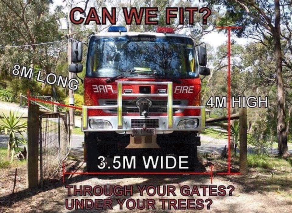
‘[But] The key point is that you cannot fit an eight metre wide road into a five metre width. The maths does not allow it. Therefore, as the ROC currently exists, the road cannot be brought up to current bush fire regulation standards.’
The failure of the ROC to meet the bushfire regulations has since been acknowledged in the updated report by another bushfire assessor, Peter Thornton.
His report now states, ‘The existing carriageway does not fully comply with… Planning for Bushfire Protection 2006, most notably passing bays with a total width of 6m are not provided.’
Mr Thornton has since advised through his solicitor Sean Radburn that, ‘Passing bays are only required to be six metres wide not eight metres wide’.
‘This is clearly set out in the acceptable solutions of Section 4.1.3(2) of the Guidelines, Planning for Bush Fire Protection’.
Former councillor and neighbour Duncan Dey says, ‘The RFS pushes the responsibility for investigation into fire access directly back onto the shoulders of Council and the planning staff. Nonethe-less, the staff have refused to meet with objectors to discuss the shortcomings of the DA in its current format.’
Additionally Mr Dey says, ‘The RFS has mistakenly referred to the property as a “residential allotment”, where in fact it is zoned RU2 primarily for agriculture. It is not zoned as a residential subdivision.’
Another concern of residents is that the land would be prone to landslips if extensive road works were undertaken on steep inclines.
Ms Best adds, ‘We have not been approached by Wayne Weisse, owner of Lot 2, or any other land owners who have a ROC through our property, seeking to widen the ROC. While we support the upgrades to the exisiting legal dwelling on Lot 2, we believe it would be irresponsible of Council to approve the secondary dwelling under these conditions in a high fire danger area.’
♦ Echo journalist Aslan Shand lives on a neighbouring property to the applicant seeking the dual occupancy.
♦ This story has been updated after it originally inferred that bushfire assessor, Peter Thornton, was the author of the initial bushfire report. The Echo understands that original report was authored by Chris Lonergan from Byron Bay Planning. Additionally, the story has been updated to reflect that passing bays are only required to be six metres wide, not eight metres wide, as originally reported. The Echo apologises to Mr Thornton for the inaccuracy.
.
 For four decades The Echo has printed the stories some people loved, some people hated, and some pretended not to read. If you want us to keep telling the truth, the real truth, not the sugar-coated version. We’ll need your support to keep the presses rolling.