18.2 C
Byron Shire
March 29, 2024

Coastal erosion in Byron Bay – a solution?

Latest News

Resilient Lismore’s ‘Repair to Return’ funding

On the eve of the second anniversary of the second devastating flood in 2022, Resilient Lismore has welcomed the finalisation of its funding deed with the NSW Reconstruction Authority, which will enable the continuation of its ‘Repair to Return’ program.

Other News

Saddle Road group home DA decision this week

Plans to build Byron Shire’s first permanent group home for women and children in housing stress are moving ahead, with the development application for the project coming before Council this week.

Could the future of the Richmond River be a clean and healthy one?

Imagine a drinkable, swimmable, fishable Richmond River? That is the aim of the Richmond Riverkeepers Association.

Byron Council staff baulk at councillors’ promise of free parking for locals

Will Byron Council deliver on its pledge to make parking permits free for locals across the Shire when paid parking comes into force in Brunswick Heads?

Fresh air federal funds for Northern Rivers schools in need

Eighteen schools in the Northern Rivers division of Richmond have received $25,000 each as part of the federal government’s School Upgrade Fund, Labor Member for Richmond Justine Elliot said last week.

NORPA’s wild ride at Lismore Showgrounds

NORPA is taking audiences on an adventure outside the theatre once again, announcing it will stage its original work Wildskin in a warehouse space at the Lismore Showgrounds. A sensory, destination theatre experience, Wildskin inhabits an outrageous and unpredictable world that’s part bush-thriller, part road-trip and a whole lot of NORPA’s signature theatrical style.

Splendour 2024 cancelled

It's official, Splendour in the Grass 2024 has been cancelled.

Access track to beach Byron Bay. Photo Steven Hanson

Steve Hansen

Erosion in Byron Bay appears out of control and may have the potential to threaten the welfare of the town.

Solutions proposed over the years have included building a rock seawall and importing large amounts of sand from elsewhere.

A Council release from April 2021 indicates plans to restore sand dunes by beach scraping, sand trapping, fence restoration and dune revegetation. It is suggested that these approaches will be implemented ‘once the sand rebuilds’.

The rebuilding of the sand appears to be the core of the problem. This may be impeded by the phenomenon of ‘headland bypassing’, which occurs when sand is transported from one beach to another around an obstacle, such as a headland, and, in the absence of the appropriate conditions in terms of wave direction and strength, fails to deposit sand in the area directly behind the obstacle.
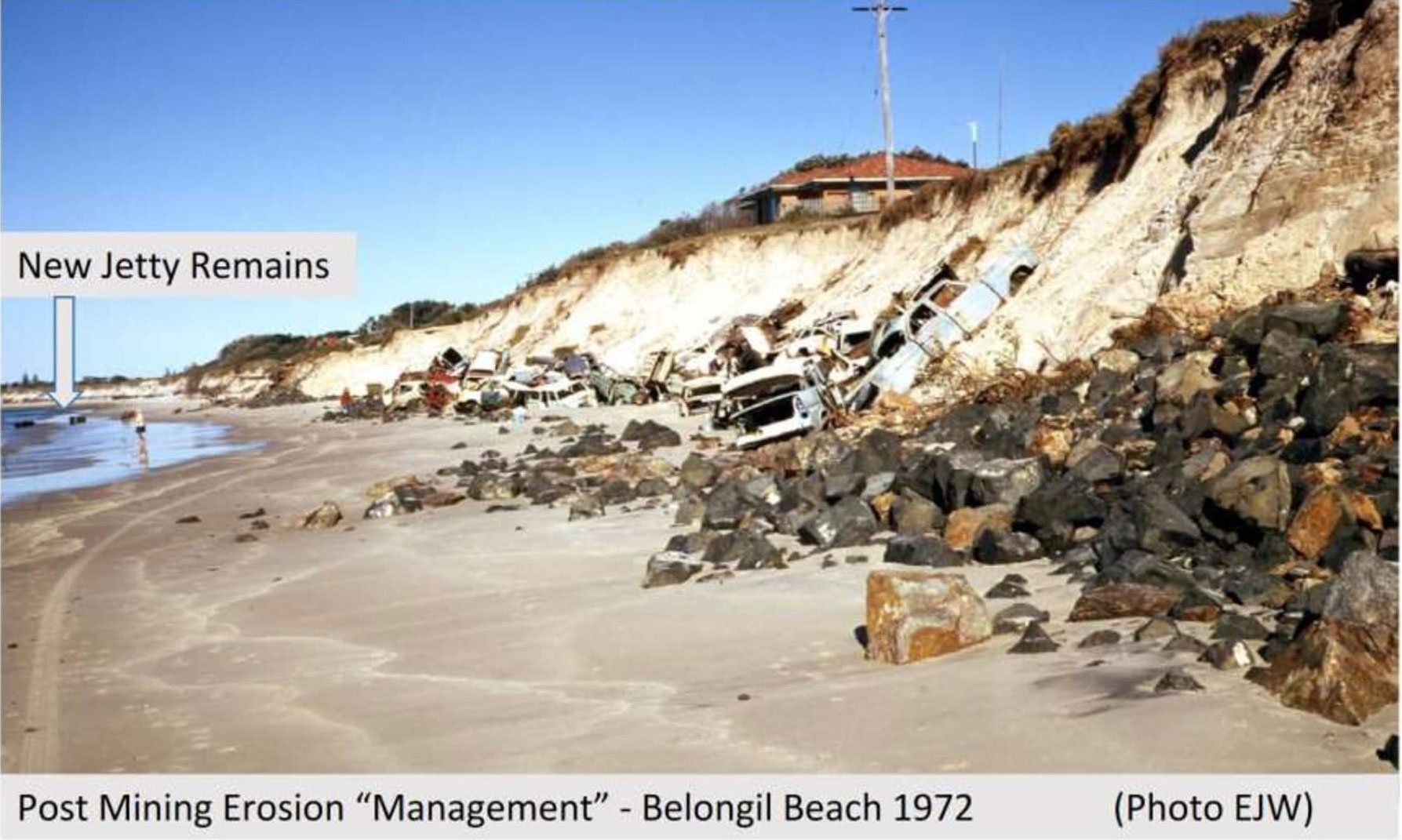
Downtown Byron post-sand mining 1971. Photo Historical Society Byron Bay

Sand mining

A study from 1991 identified a pattern of sand movement that sees sand removed by summer storms, and redistributed by winter conditions, typically resulting in a build up at Little Wategos and The Pass, and a removal of sand at Wategos and Clarkes/Main beach.

But the vegetation currently growing on the Clarkes/Main Beach foreshore may be part of the problem. After sand mining finished on the beach and in the dunes of that area in 1968, the area was left a barren wasteland until 1973, after which the dunes were reformed and revegetated.

In a healthy dune system several vegetation zones should succeed each other: a hind dune with tall trees like melaleucas should sit behind a foredune with medium-sized plants like banksias, which should sit behind a primary dune with low colonising species like spinifex.

In front of that should be a beach berm with open sand and a swash zone where waves roll up and down. It is crucial that this berm and swash zone present a low, flat profile to the sea, so that when waves surge, as they do after storms, their energy can be dissipated without doing any damage. Then as they peter out, the sand they contain can be deposited, aiding in the reinforcement of the beach structure. Loose sand can then be redistributed by the wind, further flattening the beach profile.

Sndbagged trees Byron Bay. Photo Steven Hanson

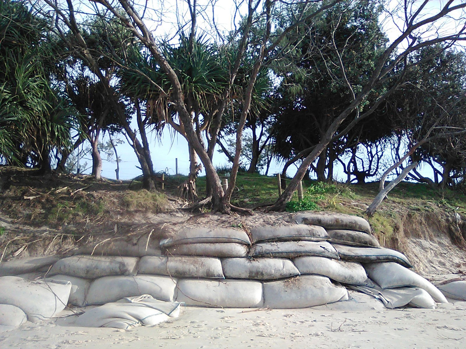
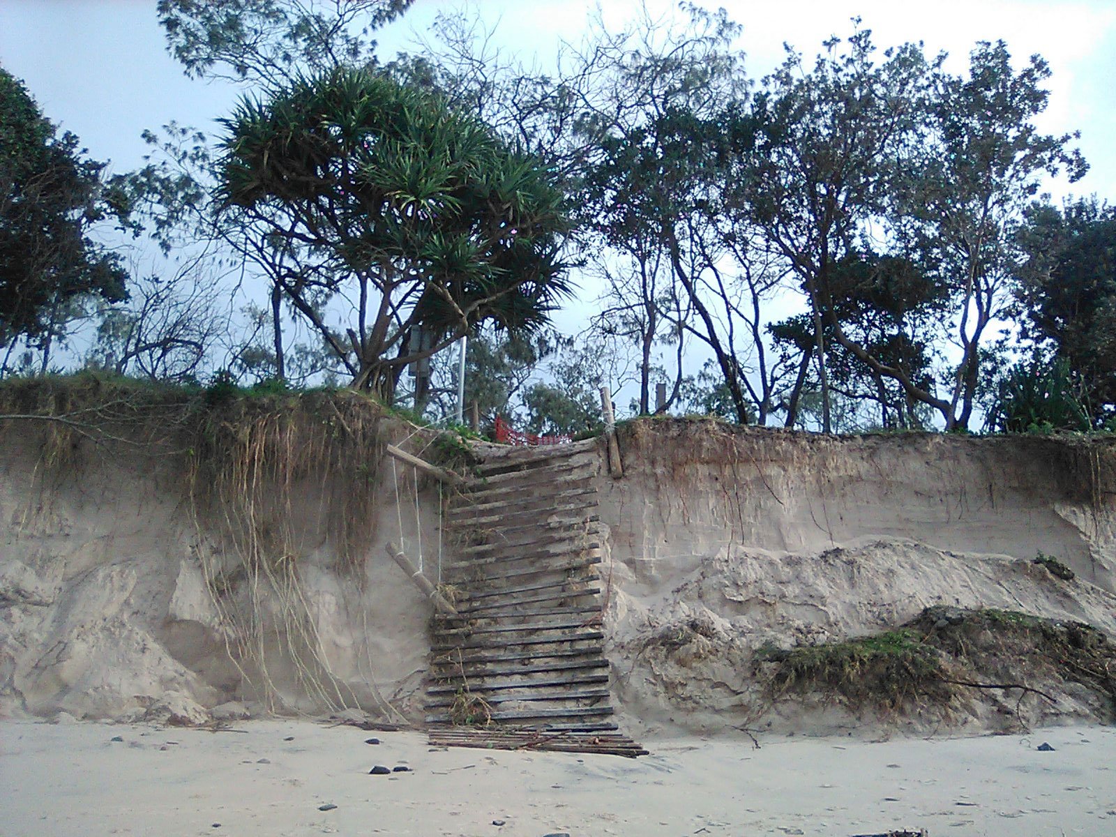
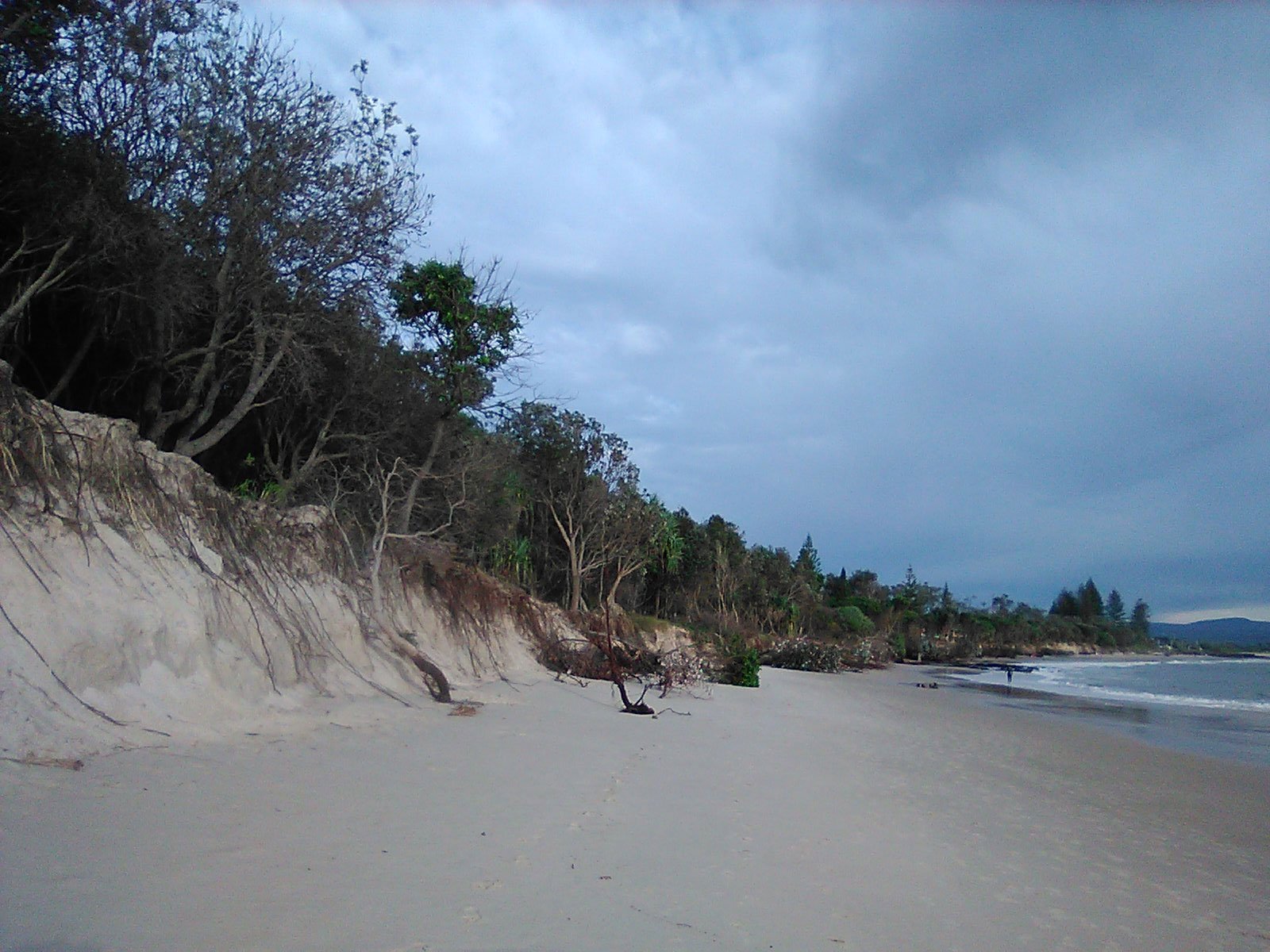
However, when vegetation grows too close to the water’s edge, wave energy is reflected by the obstacle of root-bound sand, rather than dissipated by open flat sand. This results in the removal of sand, and the development of an escarpment, as is currently the case. That escarpment then becomes self-perpetuating.

This would indicate that removing the vegetation and flattening the escarpment would be the solution.

In 2014 the council of Woonona, in southern NSW, did exactly that. Faced with deteriorating erosion, as an experiment they cleared a part of their foreshore of all vegetation, while leaving other, erosion-affected parts as they were.

The cleared area was then flattened out. When the storms came the cleared area was able to absorb the impact of surging waves, and natural processes repaired any damage done. The control areas continued to erode, and to develop larger escarpments.

Post sand mining control of erosion in Belongil in 1972. Photo Historical Society Byron Bay

Therefore the solution to our current erosion problem may well be the removal of those banksias and pandanuses still standing, and a flattening of the escarpment, rather than a reinforcing of it.

While this would be a radical remodelling of what’s left of the area between Lawson Street and the beach, this process is currently undertaken by the sea already, whether we like it or not.

The removal of vegetation goes against all our environmental conservation instincts. Would we be able to do it?

♦ Steve Hansen is a former bush regenerator and Parks and Wildlife Service ranger.


Support The Echo

Keeping the community together and the community voice loud and clear is what The Echo is about. More than ever we need your help to keep this voice alive and thriving in the community.

Like all businesses we are struggling to keep food on the table of all our local and hard working journalists, artists, sales, delivery and drudges who keep the news coming out to you both in the newspaper and online. If you can spare a few dollars a week – or maybe more – we would appreciate all the support you are able to give to keep the voice of independent, local journalism alive.

10 COMMENTS

  1. I would want to see documented evidence that it has worked elsewhere. If I was a bookie, it would be 200/1 to win out. Next, it will be Palm Beach & Barrenjoey Headland Pittwater. The consequences from failure would be quite difficult to live with. Consult the Bundjalung Mob as their viewpoint is not so economic and ego driven. Keep smilein!

  2. What does it take to get through to these people ?
    With our inevitable rise in sea-level, everything will soon be 66 meters under water.
    (David Suzuki “We’re in a giant car heading towards a brick wall and everyone’s arguing over where they’re going to sit.” )
    Plant what you like, reform or rock-wall the whole Pacific but get ready to welcome back the Whales.
    Cheers, G”)

  3. Would appreciate dates on all the photos Steve supplied. I assume the undated ones are recent? Are they?
    It was unsettling, to say the least, last time I looked back along the beach from Cook’s Beach and noticed that Lawson Street is now visible above the dune line, with not much distance left between them. Not much room there to remove vegetation and flatten the escarpment… next erosion line there will be Lawson Street. What then?

  4. Dave i would like to suggest the success of the recovery project you site , probably relied on the turning of the natural cycle of sand loss & accretion . If the cylce is in loss phaze the sea will take and take as it is doing.. whether the beach is graded to disperse wave energy or hitting a vertical berm or hitting an erosion scarp( with half a forest teetering on top. ) l dont think that demand could be calmed by trying to duplicate what the foreshore looks like in better times. After all the ideal beach profile you described is where Main beach was when the current cycle started in 2020. Plenty of sand , plenty of run up , plenty of sacrifice area.

  5. Suggest consider look at what Lennox Head did about 48 years ago by a volunteer effort using tee tree poles. The then Tintinbar council engineer noted what Bill Tresise a local did and was successful. The engineer encouraged the idea and tree tree fence was built between Lake Ainsworth and near the headland. The fence is rarely seen in the last 45 years and it worked both with preventing damage from high seas and deposited sands in windy weather.

  6. 50 years ago sea level rise by my friend and coastal geomorphology Dr Andrew Short who said sea level rise would be an inch a year. This meant that a retreat strategy should be put in place or build sea walls and have no beach. This is and will continue to be the case as witnessed in such places as Noosa. I was involved with the Townsville foreshore reclamation which involved $30 million dollars. 10 by local. 10 by state and 10 by federal funding. 20 years ago the state government planning was laughed out of town where David Kinally as councils planner was attempting to facilitate discussions on this matter with state government officials at the great northern. Such is the state of vanity of the Byron community. Until they/us are willing to get real there will continue to be no solution and the blame game will continue.

  7. Went for a bodysurf at Main Beach earlier in the year and was warned off it by the clubbies (there was a sign up saying “Beach Closed”). Went out anyway but it was REALLY dangerous as there are submerged, jagged rocks in the wave break zone. This is serious erosion and very bad for tourism.
    As to sea level rise it is about +2-3 mm per year world wide but the East coast Australian gauges only show 1-2mm/year. Why? you might well ask.
    It is still significant rise from 1972. Even if its 2mm per year that’s a total of 100mm since 1972. That’s all day, every day, every tide.
    I’d also be worried about it undermining the road near the Parks cottage, especially if I owned a place at Wategos.
    In the end there’s always the Manly Beach/Bondi solution ie lots of concrete. Or you could get self elevating scrapers to transport sand (1,000s of m3) from north of Belongil to Clarks.

  8. Removing any vegetation is very likely to be self-defeating. See US doco “The Beach, a River of Sand”, about 30 min. Fence to keep people and livestock off the foredunes, and allow summer winds to rebuild them.
    Oz sea levels are monitored by an Adelaide unit of CSIRO – look up the recent rise in your area.

  9. Steve Hansen correctly describes natural succession where gradual accretion of sand occurs. Sand-binding species are succeeded by low-growing woody species & over time by bigger trees. Ecologists call such a process a sere.
    This could conceivably happen between Clarke’s & Main Beaches. However a gradual slope is required. If the primary colonizers were establishing on the current beach level, a gradual slope would see the secondary species some tens of metres landward, at a lower elevation to that currently seen, and a climax community probably to the south of the current Lawson St alignment.
    Provided all the affected real estate can be resumed, it’s perfectly possible.

LEAVE A REPLY

Please enter your comment!
Please enter your name here

Editorial – Joyous propaganda! 

The NSW Labor government marked its one year in office this week with a jubilant statement of achievements issued from Macquarie Street HQ.

Man charged over domestic violence and pursuit offences – Tweed Heads

A man has been charged following a pursuit near Tweed Heads on Monday.

Where should affordable housing go in Tweed Shire?

Should affordable and social housing in the Tweed Shire be tucked away in a few discreet corners? Perhaps it should be on the block next to where you live?

Making Lismore Showground accessible to everyone

The Lismore Showground isn’t just a critical local community asset that plays host to a number of major events each year, but has also been used as an evacuation centre during past natural disasters in the region.