The significant flood risks for future residents at the proposed controversial Iron Gates development in Evans Head are being called out by local resident and President of the Evans Head Memorial Aerodrome Committee Dr Richard Gates.

‘Why would planning authorities ever consider it to be reasonable to build a large, isolated residential development in such “high risk” country,’ he has asked.
Dr Gates asserts that the flood assessments for the development application (DA) are inadequate and that building on the site will expose people to significant risk of both flooding and bushfire.

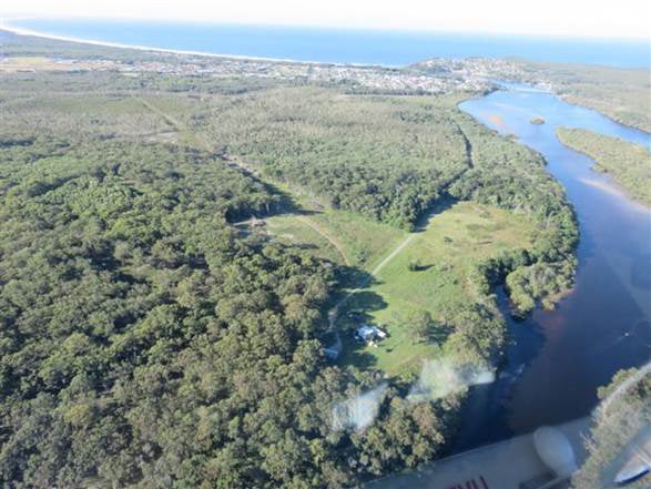
‘Part of the land on which residential development has been proposed for the Iron Gates at Evans Head is a SEPP 14 Wetland and flood plain. The one kilometre access road to the proposed development runs through wetlands and is prone to flooding. Photographic and other evidence show that part of the land proposed for residential development is also prone to flooding,’ he said.
‘The problem is potentially far worse than the current 2014 flood mapping for the Evans River suggests as the defined catchment area from formal study for flooding falls far short of the actual known catchment area.’

Dr Gates is calling for a recalculation of the flood risk for the Iron Gates site as the catchment boundary for it ‘fails to take account of a very large runoff catchment from the aerodrome itself and SEPP 14 Wetlands to the north and west of the Aerodrome. This runoff all flows through the wetland system adjacent to and on the Iron Gates Estate.’
Significant errors have been seen previously in relation to the catchment and flow directions for flooding in work commissioned by Richmond Valley Council (RVC) that led to RVC deciding to release partially treated effluent from the Evans Head sewerage treatment plant onto the active airfield at Evans Head Memorial Aerodrome. This was a result of the failure of the consultant to do a site visit. They had calculated the direction of water flows on the airfield in the opposite direction to actual flows. The proposed irrigation they had suggested would also have destroyed the existing drainage structures on the Aerodrome built during WWII.
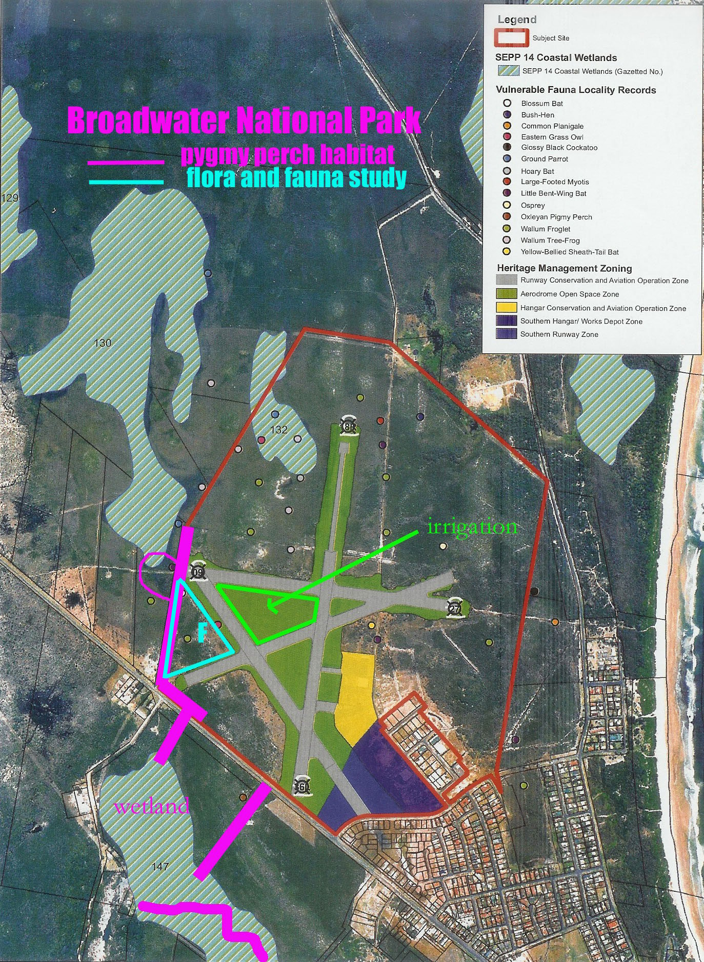
‘In our own research we were able to show that water to the west of the main north-south runway ran into a large manmade canal which had been dug along the western boundary of the airfield. That water then flowed into a waterway which ran under the Woodburn Evans Head Road and into the catchment which ran past the Iron Gates, one of two feeder waterways into that catchment.’
This work by the local community was able to stop the proposed release of partially treated effluent, destruction of the existing drainage structures and pollution of waterways containing endangered fish species.
Accurate flood assessment needed
Dr Gates said ‘that there needs to be a recalculation of the contribution of the additional catchment flows running through the Iron Gates and surrounding areas with particular attention to the changes in the flood regime with the drains dug by the developer filled in as per Land & Environment Court Order from 1997.

‘We already know that the Iron Gates floods even with the developer drain in place. That diagnosis will be much worse with the drain filled in.
‘Part of that reassessment must include the one kilometre access road to the Iron Gates which runs through wetlands. We know it floods. Existing study shows this to be the case.’

Buy back the land
Dr Gates says the State government needs to buy back the land and make it part of the surrounding National Park.
‘This is a no brainer from a planning perspective. Why would planning authorities ever consider it to be reasonable to build a large, isolated residential development in such ‘high risk’ country. The land should never have been considered for residential zoning in the first place. The rezoning occurred during the ‘white shoe brigade’ era when a lot of planning ‘mistakes’ were made.
‘The land must be rezoned and bought back from the developer by the State government to be included in the National Parks Estate. The area is a ‘wildlife corridor’ and an important cultural heritage site for the Bundjalung Nation. The buyback price should be for the unimproved capital value of the land, around $4 million, less the cost of rehabilitation of the land as per Land & Environment Court Order from 1997 estimated to be $2 million,’ he said.
 For four decades The Echo has printed the stories some people loved, some people hated, and some pretended not to read. If you want us to keep telling the truth, the real truth, not the sugar-coated version. We’ll need your support to keep the presses rolling.