24.3 C
Byron Shire
March 19, 2025

Significant flooding in Byron and Suffolk Park

Latest News

ACOSS says bold action needed to lift national living standards

The Australian Council of Social Service is calling on all political parties and candidates to commit to a bold, people-centred policy agenda ahead of the upcoming federal budget, with urgent investment in social security, housing, employment, climate action and disaster resilience.

Other News

Local midwife to improve maternal outcomes in PNG 

Local Murwillumbah midwife, Carolyn Hastie, is one of seven Australians volunteering their expertise in Papua New Guinea .

St Martin’s celebrates century

On March 25, St Martin’s Anglican Church, Mullumbimby, will proudly celebrate its 100th anniversary.

Tropical Cyclone Alfred hardship grants available

The Commonwealth and NSW government have jointly funded emergency financial assistance following Tropical Cyclone Alfred of $180 for individuals or up to $900 per family.

Yirrmal in Byron Bay

It’s not every day that you find an artist with such raw talent; a young musician who can effortlessly draw on thousands of years of culture and seamlessly translate that into beautiful, soulful and touching music.

A short history on successive governments’ lacklustre attempts at coastal protection

A government-funded study by coastal engineers into beach erosion from Byron Bay to Hastings Point warned of ongoing erosion 47 years ago, and urged governments to act to prevent further loss of property.

Urgent action needed after Ballina fish kill

Blackwater is the likely cause of a fish kill that has occurred in the Richmond River, at Ballina following ex-cyclone Alfred.

Flooding in Byron Bay 30 March, 2022. Photo Paul Blackmore

There has been extensive flooding throughout Byron Bay and Suffolk Park with the road to Ballina on the Broken Head/Coast Road cut and Shirley Street and Ewingsdale Road both flooded. There is also flooding at Brunswick Heads while Mullumbimby appears to have escaped the worst of the flooding this time.

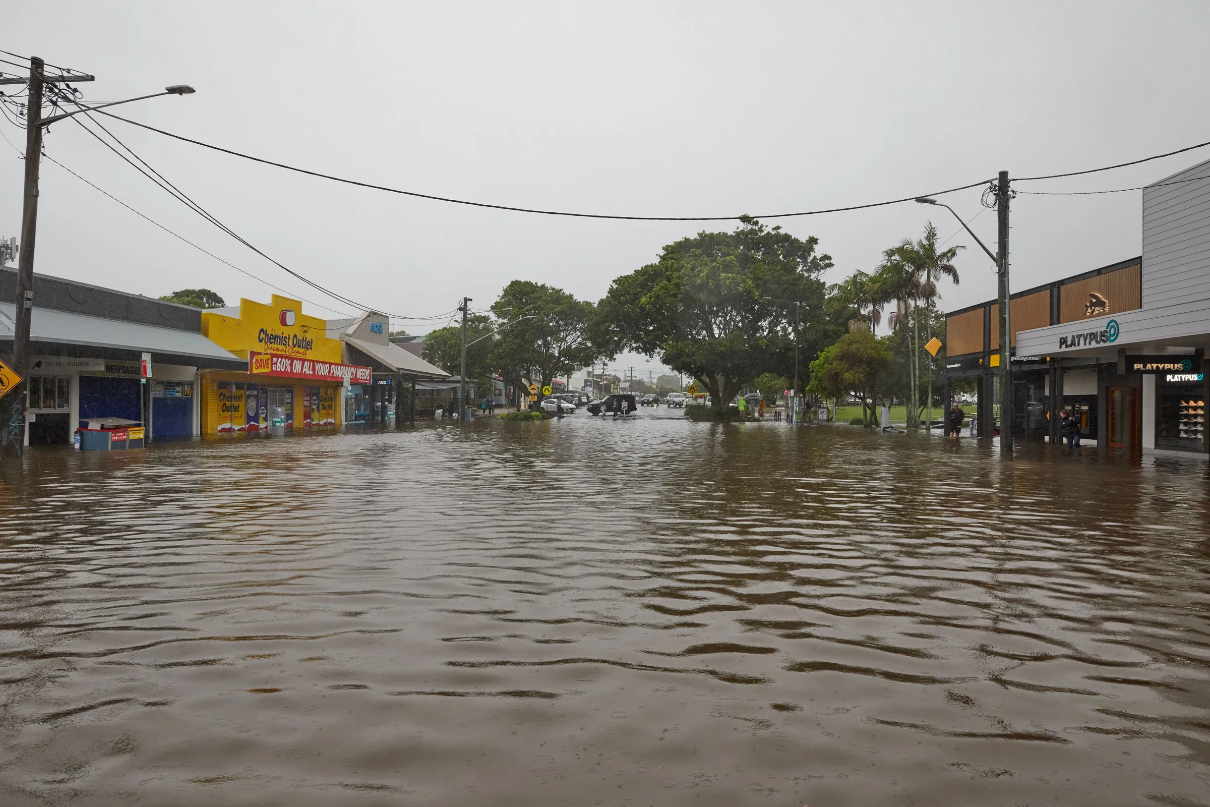
Overnight the town of Byron Bay was flooded with some shops being inundated with flood water while some people in Suffolk Park evacuating. 

Byron Cr Cate Coorey on the ground in Byron this morning (30 March, 2022) checking out the impact of the flood waters. Photo Paul Blackmore

‘At the moment all around Byron Public it is full of water and both the primary and high schools are closed today,’ said Byron Shire Councillor Cate Coorey who is on the ground in Byron Bay. 

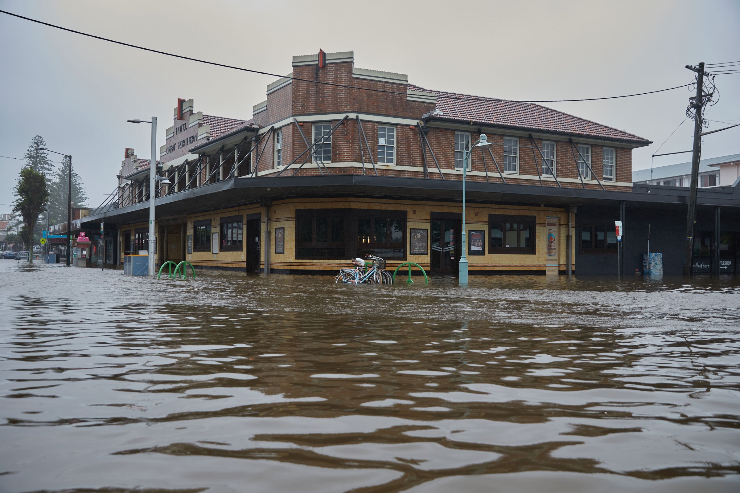
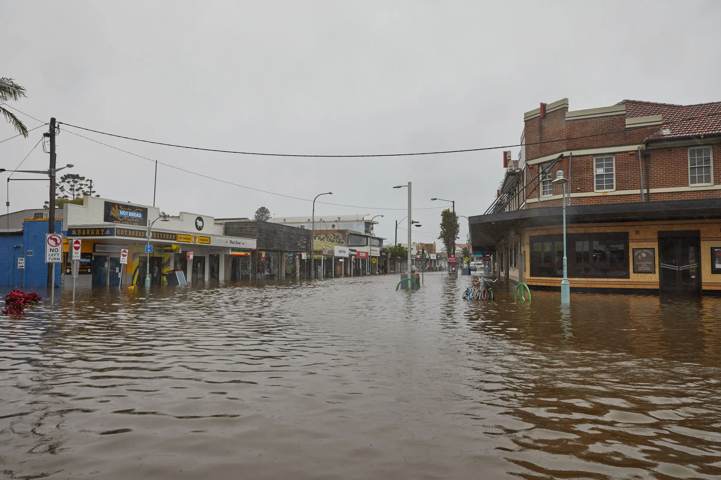
‘The southern end of Jonson Street is clear but when you get to Railway Park it is knee deep and gets deeper in Byron Street. The water is about two thirds of the way up the steps to Aldi. 

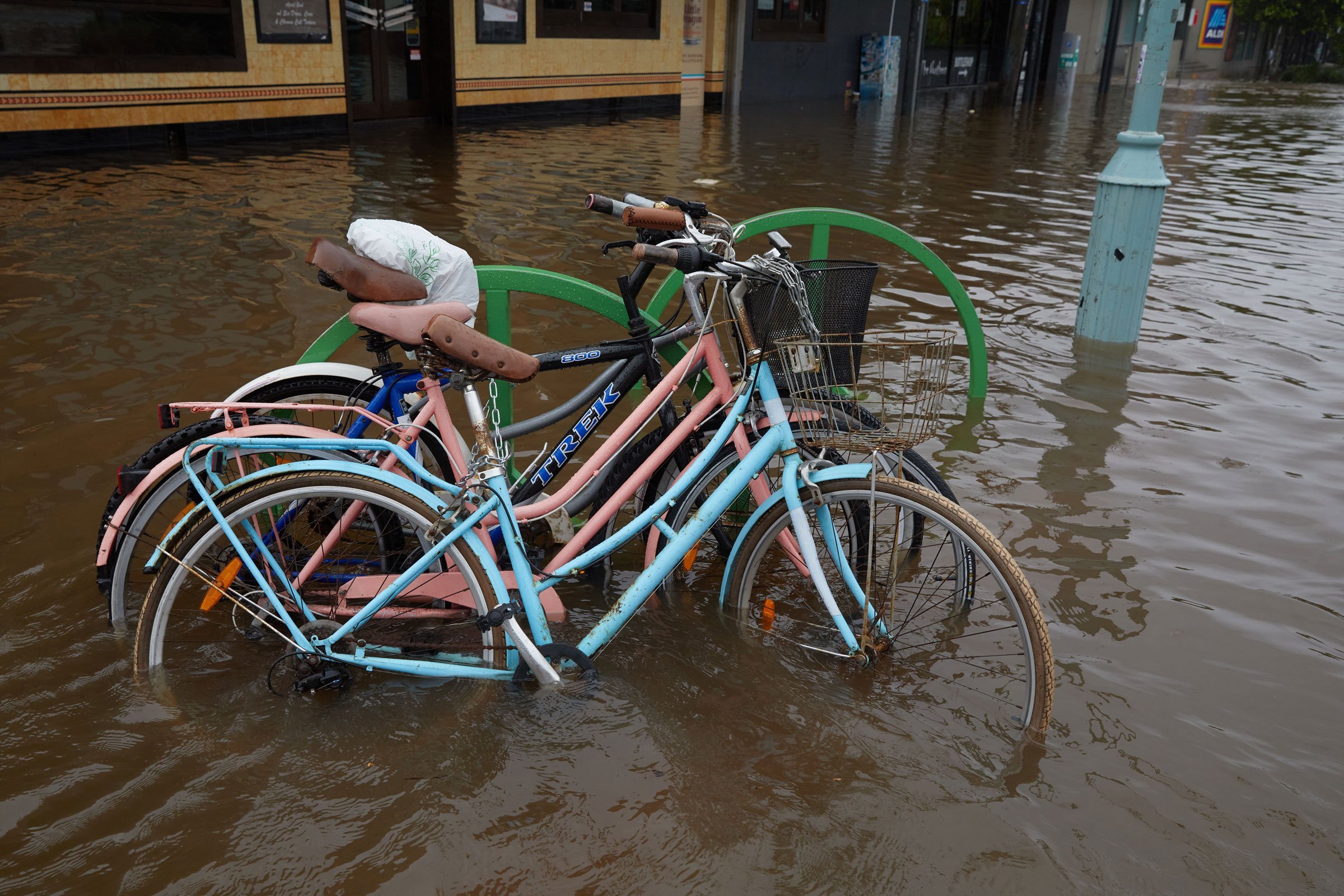
‘Everything is closed on main drag and most of the shops would have about a foot of water in them and in Byron Street I’d say there is at least a metre of water in some parts. 

Flooding in Byron Bay 30 March, 2022. Photo Paul Blackmore

‘The word unprecedented has been used many times but I don’t think anyone has seen Byron flooded like this is living memory. I urge people to be safe. Everybody keep an eye out for each other and check on your neighbours. 

‘Even though the flood water is not always deep please be careful as there is rubbish floating in it and other things that may be dangerous.’

Flooding in Byron Bay 30 March, 2022. Photo Paul Blackmore

Bodes badly for developments on floodplains like West Byron

Byron weather watcher with Masters in Climate Adaptation Robin Buckley who lives in Byron told The Echo that ‘This is almost cyclonic, the intense low is lurking around here. 

‘The local sea surface temperature although still high remains below the 26 degree that is required to call it a cyclone in this part of the world. 

‘If you look at the 128 km Brisbane (Mt Stapylton) Radar at this moment you can see rainfall band expanding with the centre of it just near Murwillumbah and it is expanding north and out to sea. It is very unusual to have such a low pressure centre here for so long. 

‘Atmospheric pressure has dropped 12.2 hPa in the last 24 hours at Byron and this is associated with severe storms such we have just experienced.’

Flooding in Byron Bay 30 March, 2022. Photo Paul Blackmore

Describing his morning loop walk through Arakwal NP starting on the ‘pipeline track’ from Paterson Street to Cosy Corner, Robin explained that ‘most of this walk is on sand and so reasonably dry but after heading south on Tallows Beach, exiting at the Beachcomber South track I was surprised to find this normally dry sandy track was waist-deep in water – this indicates a very substantial accumulated rainfall over the last one to two weeks and bodes badly for anything already built or planned to be built on floodplains such as West Byron.

‘Drainage after storm events is going to be a massive headache for all of the Northern Rivers region with increasing climate warming since even slightly elevated average temperatures allow much more moisture to be retained in the atmosphere often resulting in heavy localised downpours like the ones we have been experiencing.’

The Brunswick River has flooded over the road at the Ferry Street caravan park. Photo Daya Pepper

Brunswick Heads

Brunswick Heads has seen the Brunswick ERiver break its banks and come over the road at the Ferry Street caravan park.

‘It came over on the west side of the caravan park just after high tide at 9.23am,’ said local Daya Pepper. 

‘As far as I’m aware it hasn’t come into any of the houses so far but it has been close. I have been told that all the cabins at the front of the caravan park are currently empty as they were damaged in the last flood.’


Support The Echo

Keeping the community together and the community voice loud and clear is what The Echo is about. More than ever we need your help to keep this voice alive and thriving in the community.

Like all businesses we are struggling to keep food on the table of all our local and hard working journalists, artists, sales, delivery and drudges who keep the news coming out to you both in the newspaper and online. If you can spare a few dollars a week – or maybe more – we would appreciate all the support you are able to give to keep the voice of independent, local journalism alive.

13 COMMENTS

  1. From dim memory of the climatology I studied at uni, there is an increase in blocking highs to the east under climate change…Which would hold lows on the coast in place longer…BOM 4 day weather map has the low looking more like a cyclone 😯 maybe under climate change conditions will change that produce cyclones. They are predicted to land further south than they do. http://www.bom.gov.au/australia/charts/4day_col.shtml

  2. One possible spin-off may be that previously locked-on conservative voters may now begin to quantify the LNP’s Gas Led Recovery before voting in this upcoming election.

  3. Purely from a building design perspective this confirms my belief of decades … Never build on a concrete slab . Always elevate your home and other such buildings . Slabs only make sense to the builder … Quick to construct . One benefit ,outweighed by many disadvantages . As for bringing in fill to a wetland …. To push the water elsewhere … Goodbye sunrise and industrial estate .

  4. Submission after Submission told Byron Council that removing flood absorbent peat and replacing it with non absorbent rock fill, covered in a hard surface road, for the Byron Bypass construction, that now effectively forms a dam that restricts the previous under and overground flood flow into the Cumbebin Nature Reserve, would cause additional flooding in the Byron Bay CBD. And hey, chuck on a peat bulldosed rock filled hard surfaced bus station development on a CBD adjacent flood retention wetland, adjacent to the bypass dam, wouldnt also increase CBD flooding would it? And bulldozing the bypass/bus station carbon draw down trees wont ensure higher Council carbon emissions that will feed higher temperatures causing more evaporation and higher flood levels when it comes down, will it? The former and present Councillors that voted for the bypass and former Mayor Richardson that went to the State govt to have the Bus station there, who were all told that these developments would increase CBD flooding, are responsible for this increased height of CBD flooding, and for ensuring they added to the coming even greater floods. But hey, the bypass saved ten minutes for cars !!

  5. They quote the science on lumpy cow disease but totally ignore the 3 decades of science on global warming. If the time is not now then when is the right time to do something about it. Pretending to do something is doing nothing. Whatever gets the job done quickly and efficiently is doing something .

  6. Flood in the main street Byron to that magnitude. I would never had believed it and I just turned 70. The place looks so sole-less and soul-less. Good health, soldier on & enjoy your day (DON’T bottle-up the emotion). 70, HELL, when the skies clear I’m getting a psychological test to see if my IQ is still numerically greater than my age.

  7. For coming on 50 years I’ve watched the cyclones come through and douse Byron Bay, some more than others but all with a flood event. My observations were that storm water from the town and CBD mostly made its way to the Belongil estuary then eventually out to sea. Due to the narrow ocean outfall it caused a back up of waters which could conveniently park it self on what is now known as west byron. I’m talking about Hugh volumes of water which cover the farm fence lines for days then the water slowly disapates to sea over a mater of weeks. I am very concerned now that this west Byron land is to be filled to a height above flood levels. The town water will have no overflow reservoir which will by common sense stay in town and flood other adjacent areas for perhaps weeks . I may be wrong but I’ve always been under the impression that it’s illegal to change the height or other aspects of your property if it is going to have impact upon neighbours land.

  8. Continue David Saunders comment. In mentioning slow disapation of flood waters via the Belongil beach outlet I have missed making an important point in my last comment that the waters can only escape as fast as ocean waves and tides allow. Thanks.

    • Excellent and well explained description of the nature of living in Byron and surrounds and what happens to all the water that falls out of the sky . It’s gotta go somewhere ! If any further developments are allowed to continue in Byron or west Byron ( should that even be allowed ,it shouldn’t ) they must be raised on stilts . In south East Asia where they know how to design for monsoons it is standard .

LEAVE A REPLY

Please enter your comment!
Please enter your name here

New police response to youth crime across state

NSW Police Deputy Commissioner Paul Pisanos today announced a high-level youth strategy including 60 new dedicated police and rapid response units to tackle juvenile crime across New South Wales.

Poetry and opera for Kate’s farewell

With requests for music by Bizet, Paganini, Puccini, and Nat King Cole singing Irving Gordon’s Unforgettable, and poems by Banjo Patterson, Joyce Kilmer and Clare Harner, Kate Smorty had everything in place, for the time when she was not.

Gaming compliance checks underway across regional NSW

Liquor & Gaming NSW (L&GNSW) is conducting a compliance operation across regional NSW throughout March to ensure venues adhere to gaming regulations that promote responsible gambling and reduce harm.

Extra Reconstruction Authority services

As part of ongoing work to lead recovery operations, the Reconstruction Authority says it is rolling out additional support services to community members in and near the Byron Shire, Kyogle and Richmond Valley Local Government Areas this week.