Brought to you by Cosmos Magazine and The Echo
As the threat of extreme weather events increases, Lismore – a city that has suffered its share of historic floods – debates whether the official flood planning levels need to be increased to meet what the future might bring.
Lismore City Council trumpeted the start of a “return to normal” this week after the record floods of 2022, but has moved to recommend higher minimum floor levels for buildings in the town.
Consultants updating regional flood mapping had last month tabled a report recommending a higher Flood Planning Level (FPL) be set to allow for potentially bigger floods under climate change.
In March, the proposed changes will go to public exhibition along with the consultants’ report, a move that may go some way to ensuring a future for the settlement.
But restoring the health and wellbeing of some of the town’s residents may take a little longer.
Lismore has a long history of flooding, with at least 138 events in the past 152 years.
The heart of Lismore’s CBD was busier than I’d imagined.
Car parks were full, a bluegrass banjo player picked Soldier’s Joy from the footpath, and business owners, shoppers and café goers were (incredibly) smiling despite the events of 2022.
Some shops remained closed and empty, but many thrived.
In fact, walking down Lismore’s Keen St for coffee at Henry’s Bakery last month, I was tempted to wonder if anything had really changed at all.
My daughter was born at Lismore Base Hospital, and I’d lived and taught in the town for five years until late 1993.
Then I noticed the many small blue and white survey markers still affixed on some power poles at heights that rivalled the roof lines of nearby buildings, a reminder of how high floods had reached in the 1974 floods.
And with every step thereafter came to mind a terrifying, almost impossible image of water in the street swirling to a full two metres higher than those tell-tale markers.
Lismore has a long history of flooding, with at least 138 events in the past 152 years.
Today a city of almost 44,000, its average annual rainfall tips 1800 mm compared with 600mm Australia-wide.
Located on the lands of the Bundjalung nation, the town’s vulnerability to flooding stems from a complex set of modern factors, starting with its location as an inland port at the confluence of two rivers during the 19th century.
Today a city of almost 44,000, its average annual rainfall tips 1800 mm compared with 600mm Australia-wide.
During heavy rains, high hills surrounding Lismore return correspondingly high volumes of runoff via steep creeks to the Wilsons River and Leycester Creek, two main flood ways that join at the town.
Their combined flows navigate the Richmond River to the smaller town of Coraki before crossing a coastal floodplain to the sea at the tourist port of Ballina.
The catchment area for the Wilsons River is more than 550km2, but when Leycester Creek’s watershed is added, the catchment above Lismore climbs to 1,400 km2.
Add to these factors the growth of urban development in flood plains, changes over the years to the rivers’ profiles as well as to catchment topography and land use, and the building of levee banks to protect at-risk properties, and there emerges a complex picture of flood risk.
Read more: Floodwaters essential for ecosystem rejuvenation say experts.
Big floods, like those on Australia’s eastern seaboard in 2022, happen more often during wet La Niña years, with climate change predicted to impact their frequency, intensity, and impact.
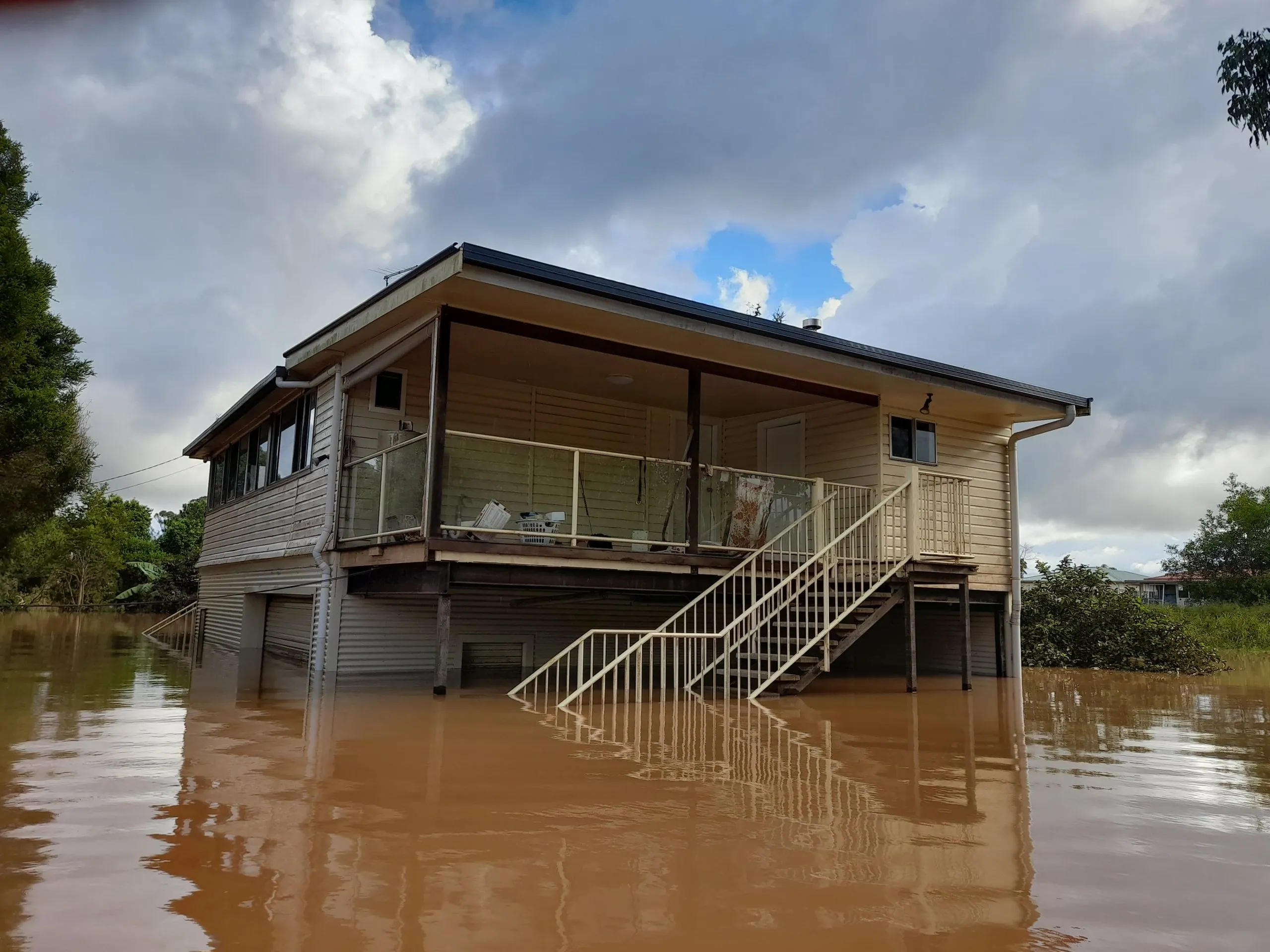
On the morning of Monday, 28 February, 2022, many Lismore people woke to some homes already flooded, and it was too late to evacuate.
The Wilson River had peaked at 14.4m, the highest flood in recorded history, more than 2 metres higher than previous records set in 1954 and 1974, and well above the town’s 10-metre-high levee wall, constructed in 2005.
Then in March it happened again – a lower peak this time but arriving while many were still cleaning up from February.
It hadn’t seemed that long since the last near record flood of 11.59m, in 2017.
The rebuild and repair bill for combined Lismore inundations of 2022 was estimated at $1 billion, a reminder that flooding is hellishly expensive.
Australia-wide in the 10 years to 2016, flooding cost us $18.2 billion per year on average, equivalent to 1.2% of average gross domestic product (GDP), a figure only likely to rise under climate change.
The rebuild and repair bill for combined Lismore inundations of 2022 was estimated at $1 billion, a reminder that flooding is hellishly expensive.
Alarmingly, the Intergovernmental Panel on Climate Change (IPCC) predicts a doubling of flooding associated with global warming of 2oC by 2100.
Even under a low emissions scenario, the cost of all types of natural disasters in Australia is expected to increase to $73 billion per year by 2060.
Which goes some way to explaining the question on many Australians’ lips this past year: Should Lismore rebuild or relocate?
If research emerging this past month is any indication, so far it’s largely the former, despite a government buyback and retrofitting scheme started late October.
A Lismore City Council occupancy audit published this week measured occupancy rates at 60% across the CBD at the end of January, compared with just 38.3% in August.
The figures were cause for hope, according to Lismore mayor Steve Kreig.
“This audit shows promising growth in the number of local businesses and organisations operating in the CBD,” Krieg said.
“It’s fair to say that we are well on the way to our pre-flood occupation rate of 90.2%.”
But problems persist, and in a separate survey released last week by Southern Cross University, researchers found that almost half of flood victims reported being still displaced by December.
Of 800 respondents to the SCU survey, more than half had moved back into a home that had flooded, 26% were living either in caravans, sheds, or pods, or with friends and family; 18% were in insecure or crisis accommodation such as tents or temporary rentals; and 4% had left the region.
Moreover, executive director of non-profit community group Resilient Lismore Elly Bird said only 20 percent of respondents were coping with the stresses and challenges of recovering from the floods.
“More than 80 per cent agree that community hubs have been essential to their recovery,” Bird says.
Now, on the eve of the first anniversary of the record flood, the community faces what may prove its greatest challenge: How do we plan for climate change?
Is it any wonder?
Five lives were lost in the 2022 Lismore floods.
More than 31,000 people were displaced, 3000 businesses disrupted, and water, sewage, and power utilities were extensively damaged.
According to a June 2022 review of the emergency, some 18,000 jobs were affected, almost 1000 of them agricultural, nearly 1400 houses in Lismore were damaged and at least 37 destroyed.
An estimated 90% of the district’s 1200km road network was eroded or washed out.
Other areas of NSW and southeast Queensland were also flooded, prompting the NSW Government to commission an independent expert inquiry into events across NSW, published in August.
A multi-million dollar CSIRO flood mitigation study of the Northern Rivers was commissioned in April, and commenced community and stakeholder consultation in October.
But the herculean challenges faced by first responders, relief workers, volunteers and recovery teams remain quite unthinkable.
Now, on the eve of the first anniversary of the record flood, the community faces what may prove its greatest challenge: How do we plan for climate change?
Read more: Rebuilding for flood resilience.
The planning challenge was made public last month when an interim flood planning report was tabled at a committee meeting of Lismore City Council (LCC) on 24 January.
Prepared by Brisbane-based water and environmental consultants Engeny Water Management Pty Ltd, a Lismore Floodplain Risk Management Plan (FRMP) had first been commissioned in 2021 but flooding in 2022 delayed the work.
Last month’s interim report made recommendations to help LCC begin shaping its land use planning and development controls for a future Lismore.
It also reported on further computer modelling for higher return period floods than the 1% or 1 in 100 AEP flood, including the simulation of 1 in 1,000, to 1 in 100,000 AEP extreme flood events.
The purpose was to update flood estimates and develop “a full set of flood planning maps for Lismore”.
Hydrologists and land planners use the Annual Exceedance Probability (AEP) to measure how likely it is that a given sized flood might occur in any one year.
The analysis uses historical flood records and computer modelling of past and likely future floods.
According to Queensland’s Chief Scientist, “nearly everywhere in Australia uses the 1% AEP event, or ‘1 in 100 year flood’, with an appropriate additional height (or freeboard) for buildings designated as having an ‘acceptable’ risk for planning purposes.”
Actual flood levels can vary from one location or street to another, and so are mapped to advise residents and insurers of a property’s risk of inundation.
For example, if a street is mapped as being in a 1% AEP flood zone, insurers estimate you have a “50% chance of being flooded in a typical lifetime (70 years), and a 15% chance of being flooded twice in this period”.
This does not necessarily mean you will be flooded once every hundred years, but that there is a 1% chance you might, for any given year, hence the term 1% AEP flood.
“IPCC research indicates that long-term weather projections point to increased intensity of rainfall events, and resultant increased risk of flooding.”
Engeny Water Management Pty Ltd
Of critical importance is the Flood Planning Level (FPL), a height used to set floor levels for property development in flood-prone areas, which for Lismore is currently set at the 1% AEP flood event plus a freeboard of 500mm.
But as Engeny notes: “IPCC research indicates that long-term weather projections point to increased intensity of rainfall events, and resultant increased risk of flooding.”
The change could raise flood levels by up to 600 mm by 2090.
At its Ordinary Meeting on Tuesday night <14th Feb>, the Lismore City Council agreed to follow Engeny’s lead and recommend raising the FPL to 1% AEP 2090 climate change level plus 500 mm freeboard.
Engeny notes the 1% AEP 2090 Climate Change levels are generally 500-600 mm above current 1% AEP flood levels.
Council advised it will also prepare a draft Development Control Plan (DCP) for Flood Prone Lands, to be publicly exhibited along with Engeny’s Interim Report.
Lismore Councillors are due to be briefed on the matter on 7 March and decide on the dates for public exhibition then, with recommendations to be exhibited for 28 days from mid-March.
Whatever the outcome, it’s clear that the lessons being learned right now by scientists, planners, researchers, and community groups in New South Wales’ Northern Rivers region, are vital to Australia’s future.
This article was originally published on Cosmos Magazine and was written by Glenn Morrison. Dr Glenn Morrison is an award-winning journalist, researcher, and author who has written of Australia’s Centre and North for more than 25 years. A former newspaper editor, he has degrees in Science, Engineering and a PhD in media and cultural studies, and has lectured at several universities. As an adjunct senior research fellow at Charles Darwin University’s Northern Institute he is general editor of Borderlands, a literary journal of the Northern Territory. Glenn has written two books about the Red Centre and lives at Alice Springs.
 For four decades The Echo has printed the stories some people loved, some people hated, and some pretended not to read. If you want us to keep telling the truth, the real truth, not the sugar-coated version. We’ll need your support to keep the presses rolling.