
Luis Feliu
Foreshore-protection campaigners are outraged that the developer of a site proposed for subdivision of more than 80 houses at Bayside near Brunswick Heads wants to acquire a slice of public Crown land zoned for coastal habitat.
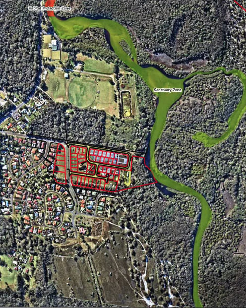
The Mills estate proposal, which has recently come off public exhibition, seeks to incorporate the Crown land into around a third of its subdivision plan for the 6.6-hectare site.
Critics say the land has already been encroached on for commercial activities (a nursery) and that agreeing to including it within the development site sends a ‘very wrong’ signal that landowners could be be rewarded for inappropriate clearing or encroachment of protected crown land.
And a report by a local historian says the the crown coastal habitat along Simpsons Creek is likely to be toxic with leachate from an old tip site (now the sports fields), just north of the proposed estate and the site is highly likely to contain major indigenous artifacts and heritage.
The development application (DA) to subdivide the land at 35 Bayside Drive into 34 lots, with a second-stage concept plan to add 50 lots later, was placed on public exhibition last month for just two weeks.
The block of land in the urban enclave of Bayside about 2.5 kilometres south of the town is owned by longtime Brunswick Valley locals John and Gloria Mills. Their existing home on the block is proposed to be retained and become part of the subdivision, known as ‘Mills Estate’.
Foreshore protection group spokesperson Michele Grant said the habitat area ‘has already been reduced by more than 50 per cent which has inevitably had an adverse impact on flora and fauna in the immediate locale’.
Ms Grant said the developer’s environmental report ‘suggests the Bayside area has significant flora and fauna, but virtually none remains on the Mills “greenfield” estate.’
‘Clearing coastal habitat lands and operating a private business without permission or prior notification is certainly not permitted, yet the Mills have used public land without any repercussions or penalty from Byron Council or Crown Lands for up to 20 years,’ she said.
‘Agreeing to the inclusion of 7B (protected coastal habitat zoning) lands within the development site would surely send a very wrong signal, will planning officers/Crown Land reps exonerate and reward landowners for the inappropriate clearing and encroachment of protected crown lands? At what cost? This is appalling.’
Ms Grant said that around 70 per cent of the Mills estate ‘is flat cleared wetlands, recently rezoned from General Rural (1AH) to R3 – Medium Density, in a process that bypassed community consultation!’
‘Approximately 30 per cent of the proposed site is crown land zoned 7B coastal habitat,’ she said.
‘The DA indicates the Mills commercial plant nursery has encroached onto 7B coastal habitat land that forms part of the wildlife corridor and adjoins Simpson’s Creek, a Marine Park Sanctuary.
‘Aerial photos (DA appendix, Land and Fire Assessment) indicate extensive land clearing and the nursery expansion onto Crown lands occurred between 1997-2007.
‘The Mills DA is now seeking to acquire all the designated 7B buffer zone/habitat area between the property boundary and Simpson’s Creek, including the public pathway, from Crown Lands for inclusion within the Mill’s development site.
‘A ring road loops through the 7B habitat area and a large stormwater drainage pond is proposed. Lots 28, 32, 37 and 41 are located within the 7B lands. The “residual lot” No 51 (19,200 square metres) is also on land zoned 7B with a dwelling site (718 square metres) proposed.
 ‘The habitat area has already been reduced by more than 50 per cent which has inevitably had an adverse impact on flora and fauna in the immediate locale,’ Ms Grant said.
In a submission on the estate’s development application, a local historian says Byron Shire Council’s proposed process for decommissioning and decontamination of the Brunswick Heads sewerage treatment plant to the north of the estate also should include the land previously occupied by the local tip.
The historian said it appeared that only ‘cursory consideration’ is given by the DA to the site’s former land use as Byron shire’s main refuse tip, from at least the mid-1950s to around 1970.
He recalled his childhood growing up on a dairy farm at Tyagarah when he often went to the tip with his father to dump all sorts of rubbish into a big eight-metre trench, including car bodies and pesticide drums.
‘As there was no regulation in those days, my father dumped drums used on the farm, such as 245T and 24D (Dieldrin),’ he said.
‘As this was once a commonly used chemical I expect many other farmers did the same.’
The historian said ’no reference is made to the extent and scale of the former Byron Shire refuse disposal area which predates the construction of the STP and the sports fields’.
‘No assessment was made or recommendations given for evaluating the extent of possible, or probable, contamination and the accurate locational position of this facility.
’Given that the old tip site was largely un-managed during its many years of operation, it could be speculated that putrefied ground, chemical residues, and harmful substances such as asbestos are present in abundance within this area.
 ‘It has long been speculated that harmful leachate from the old tip site is discharging into nearby Simpsons Creek and potentially creating a major environmental hazard.’
He said that he visited the site in 2005 and took photographs for a university assignment on waste management.
‘The photographs do not convey the stench of the leachate I observed draining from what appears to be the old tip site and only about 30 metres from the creek bank.
‘Nor do the photographs convey the extent of the surface foam adjacent to the outfall of the Brunswick Sewage (Wastewater) Treatment Works at that time. I kept the photo’s as an example of how not to manage waste,’ the submission said.
 For four decades The Echo has printed the stories some people loved, some people hated, and some pretended not to read. If you want us to keep telling the truth, the real truth, not the sugar-coated version. We’ll need your support to keep the presses rolling.